


24 nüLink! 1695 Owner’s Manual
About the Map Pages
Using the Pedestrian
Navigation Map
➋➊ ➊
➌ ➍
➎ ➎
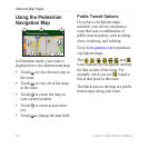
In Pedestrian mode, your route is
displayed on a two-dimensional map.
Touch
➊
to view the next step in
the route.
Touch
➋
to view all of the steps
in the route.
Touch
➌
to center the map on
your current location
Touch
➍
to zoom in and zoom
out.
Touch
➎
to change the data eld.
•
•
•
•
•
Public Transit Options
If you have cityXplorer maps
installed, your device calculates a
route that uses a combination of
public transit options, such as riding
a bus or subway, and walking.
Go to www.garmin.com to purchase
cityXplorer maps.
The , , , , , , and
icons indicate the navigation method
for that section of the route. For
example, when you see , board a
bus at that point in the route.
The black dots on the map are public
transit stops along your route.