


2. MENU OPERATION
2-14
NAV DATA MODE
Three nav data displays are available: alphanumeric, graphic1 and graphic2.
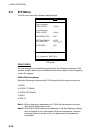
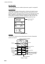
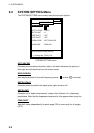
ALPHANUMERIC
The alphanumeric display provides position in latitude and longitude, course,
speed, depth, temperature, and range, bearing and cross-track error to the
destination waypoint. Appropriate sensors are required to show data other than
depth. If desired, you may enlarge one indication on one half of the screen.
Circumscribe the indication to enlarge by operating the [▲] or [▼] key, then
press the [+] key. To restore the full nav data display, press the [-] key.
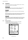
POS
34°44.135’N
135°27.098’E
CSE SPD
135° 8.6kt
DEP TMP
42.9ft 85.51°F
WP 001
RNG 79.03nm
BRG
135°
XTE
0.005
nm
Cursor for choosing
data to enlarge
Nav data display
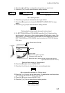
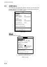
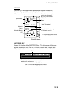
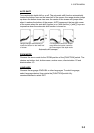
GRAPHIC1
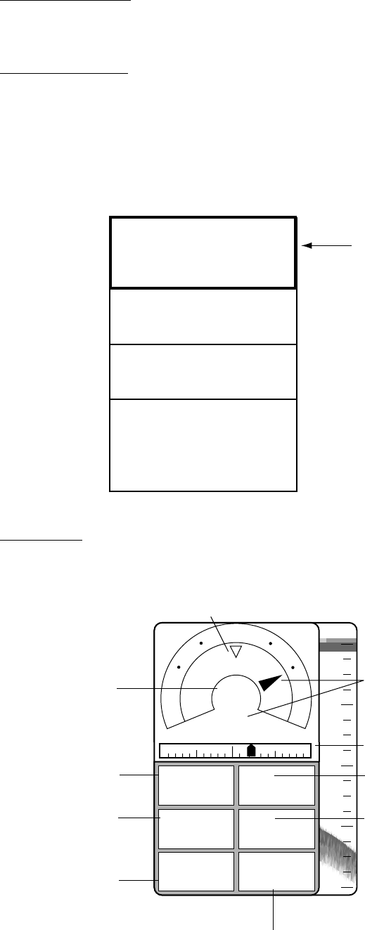
The GRAPHIC1 display mainly provides steering information. Appropriate
sensors are required.
0
20
40
60
80
DEP
69.4
ft
TMP
85.51
°F
RNG
12.0
nm
TRIP
76.8
nm
WP
ABC
SPD
8.4
kt
1nm 1nm
BRG
359
°
CSE
323
°
N
W
E
Destination
Waypoint
Range to
Destination
Waypoint
Depth
Speed*
Distance Run*
Note: Distance run may be
reset to zero by pressing
the [+] or [-] key for about
five seconds.
Water Temperature*
Cross-track Error
Bearing to Destination Waypoint
Bearing*
Course*
* = Requires appropriate sensor.
Graphic1 display