


10
SAT Page
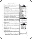
MAP Page
(with Compass layer)
Page View Details
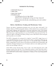
Range Ring
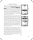
Fig. 1
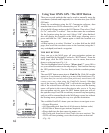
Fig. 2
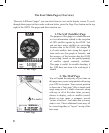
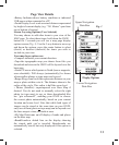
1. SAT Page View (Fig. 1)
The SAT page view is used to identify the quality or
strength of the satellite signals being received by the
unit. Navigation data boxes on the satellite page are used
to identify your location, shown as POSition (latitude,
longitude) and ELEVation (altitude above sea level). The
items displayed on the satellite page view are xed, and
cannot be changed by the user.
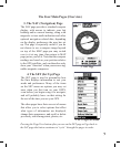
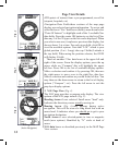
2. MAP Page View (Fig. 2)
The MAP page view is the primary page you will use
to navigate with the ONIX-. Using Bushnell’s exclusive
screen layering, this page shows all navigational
information in a single view, on one display “page”. The
following items are always displayed on this page:
•Base Map-primary streets and location, similar to a basic
road map (also see “My Map Data”, pg.11).
•Cursor-shows your location and direction. The cursor
can assume one of three shapes:
-a “bearing arrow” that shows your navigation
direction when you are moving (or heading
when you are not actively navigating)
-a circle-“you are here locator” to display your
current location relative to the map
-a “crosshairs” cursor that allows you to pan the
map, check position of waypoints or POI when
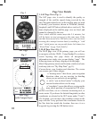
Note: initial satellite contact may take 3-4 minutes, but
will be faster on next power-up in the same area. If the
unit has been moved over 300 miles since was last used,
resetting this startup location data by enabling a “cold
start” initial power on can provide faster lock times (see
“Reset Data” on pg 14 for details).
moved over them, use as a distance measuring tool, or
create routes. If you know the latitude/longitude (or other
coordinates as selected in the SET menu under “Units”)
of a location, you can move the crosshairs cursor on the
map with the 5-way pad until the coordinates shown in
the Nav data box match the location, then save it as a
waypoint by pressing the OK button twice.