


20
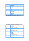
$GPZDA,hhmmss.dd,dd,mm,yyyy,xx,yy*hh
hhmmss.dd UTC time of the fix.
hh = hours.
mm = minutes.
ss = seconds.
dd = decimal part of seconds.
dd UTC day of month
mm UTC month
yyyy UTC year
xx Local zone hours. Not implemented, output always 00.
yy Local zone minutes. Not implemented, output always 00.
*hh Check sum
<CR><LF>
End
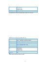
Ex.
$GPZDA,061724.46,17,04,2003,00,00*61
Part 9 Trouble shooting guide
The GPS signal will become weak under the following conditions
If the vehicle enters the tunnel.The GPS signal transmits linearly down to earth and its
signal is blocked out in this situation.
GPS satellite coverage gets poor because of high-rise building or thick forest. Even
though WBT-100 can receive reflected weak GSP signal , the data might be less accurate
The sun shade in the vehicle can partially block out GPS signal and effect good reception.
The GPS satellite is under control of USA and the accuracy might vary depending on
some special purpose(as may be required by USA)
It is a normal situation when GPS data displayed by the receiver device shows a big
difference from real position because of unstable atmospheric condition which causes
GPS axis to drift from actual map axis occasionally
Some navigation softwares can only decode latitude/latitude from NMEA0183 provided by
logger. No altitude information is available and therefore it cannot define vehicle’s positioin
whether the is over or under the bridge.
After successful positioning of WBT-100, if it is moved to another area of 500 km away it
cannot be easily re-positioned. This is because the firstly recorded data(position, time and
number of satellites acquisitioned) is different from the new area. It will need longer time
for re-positioning.