


17
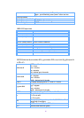
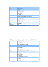
$GPGSV,n,m,ss,xx,ee,aaa,cn,…………. ,xx,ee,aaa,cn*hh<CR><LF>
n Total number of messages, 1 to 3
m Message number, 1 to 3
ss Total number of satellites in view
xx Satellite ID (PRN) number
ee Satellite elevation, degrees 90 max
aaa Satellite azimuth, degrees True, 000 to 359
cn Signal-to-noise rations (C/No) 00~60 dB-Hz. Value of zero
means that the satellite is predicted to be on the visible sky
but it isn't being tracked.
*hh Check sum
<CR><LF>
End
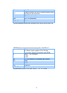
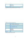
Ex:
$GPGSV,4,1,14,03,66,207,50,08,09,322,44,11,01,266,42,14,00,155,00*79
$GPGSV,4,2,14,15,41,088,48,17,21,083,44,18,57,087,51,21,57,173,50*78
$GPGSV,4,3,14,22,05,203,00,23,52,074,49,26,17,028,44,27,00,300,00*79
$GPGSV,4,4,14,28,32,243,00,31,48,286,00*70
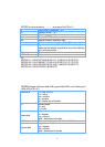
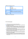
$GPRMC,hhmmss.dd,S,xxmm.dddd,<N|S>,yyymm.dddd,<E|W>,s.s,h.h,ddmmyy,d.d,
<E|W>,M*hh<CR><LF>
hhmmss.dd UTC time of the fix.
hh = hours.
mm = minutes.
ss = seconds.
dd = decimal part of seconds.
S Status indicator
A = valid
V = invalid
xxmm.dddd
Latitude coordinate.
xx = degrees.
mm = minutes.
dddd = decimal part of minutes.
<N/S> Character denothing either N = North or S =South.
yyymm.dddd
Longitude coordinate.
yyy = degrees.
mm = minutes.
dddd = decimal part of minutes.