


17
LA000507G © 2006 Navman New Zealand. All rights reserved. Proprietary information and specications subject to change without notice.
10.0 Ordering information
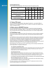
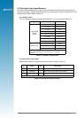
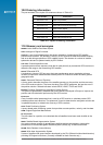
The part numbers of the Jupiter 20 variants are shown in Table 10‑1.
Part Number Description
TU20‑D411‑001 Jupiter 20 (standard)
TU20‑D411‑101 Jupiter 20S (with XTrac)
TU20‑D421‑201 Jupiter 20D (with Dead Reckoning)
TU20‑D101‑001 Jupiter 20 std adapter
TU10‑D007‑400 Jupiter 20 std development kit
TU10‑D007‑401 Jupiter 20S development kit
TU10‑D007‑402 Jupiter 20D development kit
Table 10-1: Jupiter 20 ordering information
11.0 Glossary and acronyms
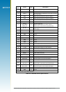
2dRMS: twice distance Root Mean Square
ADC: Analogue to Digital Converter
Almanac: A set of orbital parameters that allows calculation of approximate GPS satellite
positions and velocities. The almanac is used by a GPS receiver to determine satellite visibility
and as an aid during acquisition of GPS satellite signals. The almanac is a subset of satellite
ephemeris data and is updated weekly by GPS Control.
C/A code: Coarse Acquisition code
A spread spectrum direct sequence code that is used primarily by commercial GPS receivers to
determine the range to the transmitting GPS satellite.
DGPS: Differential GPS
A technique to improve GPS accuracy that uses pseudo‑range errors recorded at a known
location to improve the measurements made by other GPS receivers within the same general
geographic area.
GDOP: Geometric Dilution of Precision
A factor used to describe the effect of the satellite geometry on the position and time accuracy
of the GPS receiver solution. The lower the value of the GDOP parameter, the less the error in
the position solution. Related indicators include PDOP, HDOP, TDOP and VDOP.
EGNOS: European Geostationary Navigation Overlay Service
The system of geostationary satellites and ground stations developed in Europe to improve the
position and time calculation performed by the GPS receiver.
Ephemeris
A set of satellite orbital parameters that is used by a GPS receiver to calculate precise GPS
satellite positions and velocities. The ephemeris is used to determine the navigation solution and
is updated frequently to maintain the accuracy of GPS receivers.
GPS: Global Positioning System
A space‑based radio positioning system that provides accurate position, velocity, and time data.
OEM: Original Equipment Manufacturer
Re-acquisition
The time taken for a position to be obtained after all satellites have been made invisible to the
receiver.
SBAS: Satellite Based Augmentation System
Any system using a network of geostationary satellites and ground stations to improve the
performance of a Global Navigation Satellite System (GNSS), e.g. EGNOS and WAAS.
SRAM: Static Random Access Memory
WAAS: Wide Area Augmentation System
System of satellites and ground stations developed by the FAA (Federal Aviation Administration)
providing GPS signal corrections. (Currently available for North America only.)