


39Magellan Meridian GPS Receiver
Reference
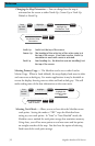
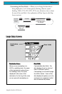
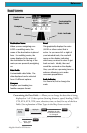
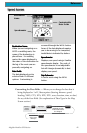
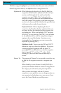
Customizing the Data Fields — Allows you to change the data that is being
displayed to 1 of 13 data options (bearing, distance, speed, heading, VMG,
CTS, ETA, ETE, XTE, turn, elevation, time, or date) for any of the four
fields. (See explanation of Data Types in the Map Screen section.)
From the
Road
Screen
MENU
Highlight
Customize
Use arrows to
highlight the title
for the data field to
be changed
Use arrows to
select new
data type
ENTERENTER
ENTER
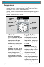
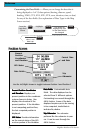
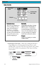
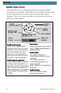
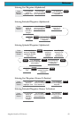
Customizable
Data Fields
Destination
Name
Scale Indicator
Compass
Road
Destination NameDestination Name
Destination NameDestination Name
Destination Name
When you are navigating on a
GOTO or multileg route, the
name of the destination is placed
here. For multileg routes, the
name displayed is the name of
the destination for the leg of the
route you are presently navigating
on.
Data FieldsData Fields
Data FieldsData Fields
Data Fields
Customizable data fields. The
data displayed can be selected
from 13 different options.
CompassCompass
CompassCompass
Compass
Displays your heading in a
familiar compass format.
RoadRoad
RoadRoad
Road
This graphically displays the route
(GOTO or other routes) that is
active. As you move left or right of
your intended track, the road will
move on the display indicating
which way you need to steer to get
back on track. Ideally, the road
would be centered on the display.
Also, you will see upcoming turns in
advance allowing you to make
necessary preparations.
Scale IndicatorScale Indicator
Scale IndicatorScale Indicator
Scale Indicator
Use Zoom In/Out to change the
scale.