


26 Magellan Meridian GPS Receiver
Reference
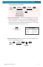
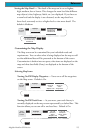
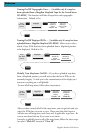
Tu rning On/Off Topographic Lines — [Available only if a map has
been uploaded from a Magellan MapSend Topo for the United States
CD-ROM] This function will hide all topo lines and topographic
information. Default is On.
From
the MAP
Screen
MENU
Highlight
Map Setup
Use L/R
arrows to
select
“Display” tab
ENTER
Use U/D
arrows to
select “Topo
Lines”
ENTER
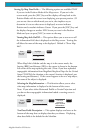
Tu rni ng On/Off Displayed POI’s — [Available only if a map has been
uploaded from a Magellan MapSend CD-ROM] Allows you to select
which, if any, POIs that have been uploaded from a MapSend product
to be displayed. Default is On.
From
the MAP
Screen
MENU
Highlight
Map Setup
Use L/R
arrows to
select
“Display” tab
ENTER
Use U/D
arrows to
select POI
ENTER
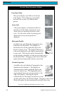
Globally Turn Map Items On/Off — If you have uploaded map data
from a MapSend product, you will notice that the list of POIs can be
extremely lengthy. To aide you in the customization of the display you
can turn everything on or off globally.
To turn off all map items, follow these instructions.
From
the MAP
Screen
MENU
Highlight
Map Setup
Use L/R
arrows to
select
“Display” tab
ENTER
Use U/D
arrows to
select
Clear All
ENTER
After you have turned off all of the map items, you can go back and just
select the POIs that you want to view. Please note that this function
will also turn off waypoints, track lines and, if applicable, topo lines. Be
sure to turn these back on if you want to see them.
Inversely, to globally turn on all of the map items, follow the above steps
but select “Mark All” instead of “Clear All”.