


7
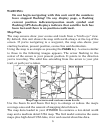
The low-detail world map contains some large cities and most country
political boundaries. The medium-detail U.S. map contains: all
incorporated cities; shaded metropolitan areas; county boundaries;
some major city streets; Interstate, U.S. and state highways; lakes and
streams and more than 60,000 navigation aids and 10,000 wrecks and
obstructions in U.S. coastal and Great Lakes waters. The map also
contains exit services information for Interstate highways.
The iFINDER Go2 International contains a worldwide reference map
with basic coverage of country political boundaries, major lakes, rivers
and coastal waters, plus key cities, and major and minor highways.
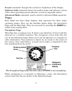
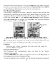
Moving Around the Map: Zoom & Cursor Arrow Keys
The map is presented from a bird's eye view perspective. The current
zoom range shows in the lower left corner of the screen.
1. Press the
ZIN key (zoom in) to move in closer and see greater detail in a
smaller geographic area.
2. Press the
ZOUT key (zoom out) to move farther away and see less map
detail, but a larger geographic area.
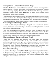
When you are walking or riding in a vehicle, the map will automatically
move as you move. This keeps your current location roughly centered
on the screen.
You can manually pan or scroll the map northward, southward,
eastward or westward by using the arrow keys, which launches the
cross-hair map cursor. This allows you to look at map places other than
your current position. To clear the cursor, press
EXIT, which jumps the
map back to the current position or the last known position.
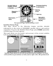
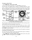
Selecting Any Map Item with the Cursor
1. Use the zoom keys and the arrow keys to move around the map and
find the item you wish to select.
2. Use the arrow keys and center the cursor cross-hair on the desired
object. On most items, a pop-up box will give the name of the selected item.
You will also notice a black ring surrounds the item as it becomes