


6
WARNING:
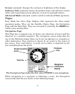
Do not begin navigating with this unit until the numbers
have stopped flashing! On any display page, a flashing
current position indicator/question mark symbol and
flashing GPS data displays indicate that satellite lock has
been lost and there is no position confirmed.
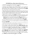
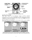
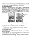
Map Page
The map screens show your course and track from a "bird's-eye" view.
By default, this unit shows the map with north always at the top of the
screen. If you're navigating to a waypoint, the map also shows your
starting location, present position, course line and destination.
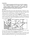
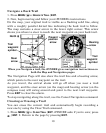
Using the map is as simple as pressing the
PAGES key. A screen similar
to those in the following images appears. The arrow flashing in the
center of the screen is your present position. It points in the direction
you're traveling. The solid line extending from the arrow is your plot
trail, or path you've taken.
Map Page screen and various zoom levels.
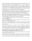
Use the Zoom In and Zoom Out keys to enlarge or reduce the map's
coverage area and the amount of mapping detail shown.
The map data loaded in your iFINDER Go contains a low-detail world
map and a medium detail USA map. The Go2 model contains the same
maps plus high detail USA lake, river and coastal shoreline data.