


83
which display latitude and longitude grid lines or range rings on the
map. This menu lets you select Navionics Maps. For instructions, see
the Navionics Charts entry in this section.
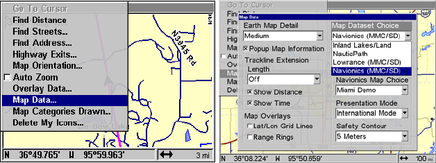
To get to Map Data:
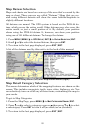
From the Map Page, press
MENU|↓ to MAP DATA|ENT.
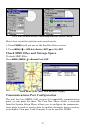
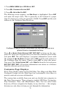
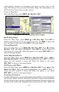
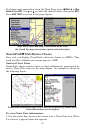
Map Menu (left) and Map Data Menu (right).
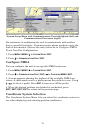
Earth Map Detail
From the Map Page, press
MENU|↓ to MAP DATA|ENT. Press ENT to
check to select the level of map detail you prefer. Use ↑ ↓ to choose off,
low, medium or high, then press
EXIT to the page display.
Pop-up Map Info
From the Map Page, press
MENU|↓ to MAP DATA|ENT. Press ↓ to POPUP
MAP INFO. With the option highlighted, press ENT to check it (turn on)
and uncheck it (turn off). After the option is set, press
EXIT|EXIT to re-
turn to the page display.
Draw Map Boundaries
From the Map Page, press
MENU|↓ to MAP DATA|ENT. Press →|↓ to
DRAW MAP BOUNDARIES. With the option highlighted, press ENT to check it
(turn on) and uncheck it (turn off). After the option is set, press
EXIT|EXIT to return to the page display.
Fill Water with White
From the Map Page, press
MENU|↓ to MAP DATA|ENT. Press →|↓ to FILL
WATER WITH WHITE. With the option highlighted, press ENT to check it
(turn on) and uncheck it (turn off). After the option is set, press
EXIT|EXIT to return to the page display.
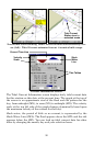
Trackline Extension
Trackline Extension is a new tracking option that provides a visual interpreta-
tion of your velocity. It charts how long it will take to travel a predetermined
distance based on your current navigational information. Distance is shown on
one side of the track with estimated time of arrival on the other. Below the