


85
To turn on/off range rings:
1. From the Map Page, press
MENU|↓ to MAP DATA|ENT.
2. Press ↓, → to
RANGE RINGS. With the option highlighted, press ENT to
check it (turn on) and uncheck it (turn off.)
3. After the option is set, press EXIT|EXIT to return to the page display.
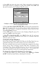
To turn on/off Lat/Long Grid lines:
1. From the Map Page, press
MENU|↓ to MAP DATA|ENT.
2. Press ↓, to
LAT/LON GRID LINES. With the option highlighted, press ENT
to check it (turn on) and uncheck it (turn off.)
3. After the option is set, press
EXIT|EXIT to return to the page display.
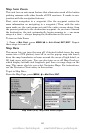
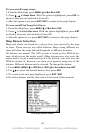
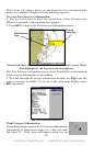
Map Datum Selection
Maps and charts are based on a survey of an area covered by the map
or chart. These surveys are called Datums. Maps using different da-
tums will show the same latitude/longitude in different locations.
All datums are named. The GPS system is based on the WGS-84 da-
tum, which covers the entire world. Other datums may also cover the
entire world, or just a small portion of it. By default, your unit uses the
WGS-84 datum. It, however, can show your position using any of 191
datums. Different datums can be selected. To change the datum:
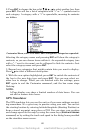
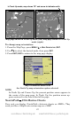
1. Press
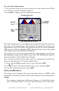
MENU|MENU|↓ to GPS SETUP|ENT|↓ to DATUM SELECTION|ENT.
2. Use ↓ ↑ to select the desired datum, then press
ENT.
3. To return to the last page displayed, press
EXIT|EXIT.
A list of the datums used by this unit is in the back of this manual.
The Map Datum Menu.
www.Busse-Yachtshop.de email: info@busse-yachtshop.de