


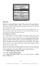
82
Steer with Arrows
When you are using the Steer with Arrows command, you can press
EXIT to clear the steering and speed boxes from the screen while con-
tinuing the simulation. This action will allow you to use the map cursor
during a simulation. To turn steering and speed boxes back on again,
return to the GPS Simulator menu, highlight the
STEER WITH ARROWS
command, press
ENT. Press EXIT repeatedly to return to the previous
page.
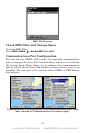
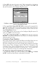
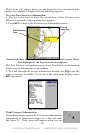
Simulating Trail or Route Navigation
In Simulator mode, your unit can automatically follow a trail or route
without manual steering if you use these steps:
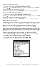
1. From the Map Page, go to the simulator menu. Pick a STARTING POSI-
TION
at or near the beginning of your trail/route. Enter an approximate
TRACK (shown in compass degrees) that will point you toward the start
of the trail/route.
2. Set
SPEED to zero. Select STEER WITH ARROWS command and press ENT,
which turns on the simulator and returns you to the Map Page.
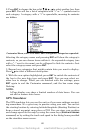
3. Begin navigating along the trail/route. (If you are close enough to the
first waypoint, the arrival alarm will usually go off as soon as naviga-
tion begins. Press
EXIT to clear the alarm.) When navigation starts,
press ↑ to increase speed to the desired setting.
4. Press
EXIT to turn off the steering and speed boxes. The unit will now
automatically steer along the trail or route. Cancel navigation when
you arrive at your destination.
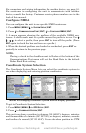
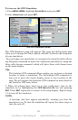
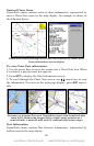
Initialize GPS
This command is handy when you are practicing in simulator mode. (See
the entry in this section for GPS Simulator.) In simulator mode, this
command makes the unit operate as if it is sitting someplace other than
its actual location. So, you and your unit could be located in Kansas City,
but easily practice navigating in the ocean off Islamorada, Florida.
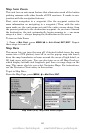
1. Press
MENU|MENU|↓ to GPS SETUP|ENT|ENT.
2. A message appears, telling you to move the cursor near the desired
location and press
ENT. When the message automatically clears, follow
the message instructions.
3. In a moment, your present position marker arrow appears on the
map in the location you selected with the cursor. The unit will consider
that spot as its last known position until changed by either a live satel-
lite lock-on or a new simulator location.
www.Busse-Yachtshop.de email: info@busse-yachtshop.de