


GPS (GLOBAL POSITIONING SYSTEM)
What is GPS?
GPS, standing for Global Positioning System, is becoming common nowadays. Following is a brief introduction.
The American Defense Department developed GPS originally for military operations. The system is available for use by
the general public. For example, anybody can use GPS in association with modern vehicle navigation systems. Position
precision for public use is approximately 15 m.
Moreover, precision can be improved when a vehicle is used for navigation and aboard ships through use of map
matching technology and differential GPS techniques.
A total of 24 or more GPS satellites are at a high-level altitude of approximately 20,000 km on six circular tracks with an
orbital radius of approximately 26,000 km. Therefore, there are four or more satellites located in each orbital track. For
civilian use, the RF carrier frequency of the satellites is 1575.42 MHz. Spread spectrum (SS) technology is used over a
bandwidth of 2.046 MHz to prevent interference among all the satellite signals on a common carrier frequency.
Datum (Geodetic Survey System)
The GPS receiver receives the radio signals transmitted from the GPS satellites. The receiver measures the time duration
between when the signal leaves the satellite and when the signal arrives at the GPS receiver. Knowing this time allows
calculation of the distance that the signal traveled from that particular satellite. By receiving multiple signals from different
satellites and doing this distance calculation multiple times, the intersection of the spherical surfaces that represent the
respective radius distances to the various satellites will determine a single point.
The precision of the determination of the intersecting point relies on the satellites and the data collected.
Position Determination Principle
The latitude and longitude information required by the GPS receiver does not allow for accurate representation of the
unevenness of the Earth’s surface. For use with GPS, the current standard that defines the precise shape of the Earth is
called WGS-84. By using this standard in conjunction with mapping standards for each country, accurate position plotting
on a map can be done.
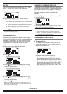
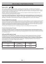
GPS and APRS Position Format
Although position can be described in many different formats, such as degrees, degrees and minutes, and degrees,
minutes and seconds, the GPS system and APRS have standardized on the degrees and decimal minutes format.
Just like it is important to use proper international phonetics when spelling on the air, it is important in APRS as in any
communications system to have a default standard for position. All operators should be trained to use the DDD MM.mm
format by default in voice communications just like in data formats. Using these standards on the air will prevent
communications errors, confusion, repeats, and conversions.
Interval and Total Distance
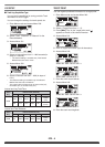
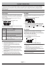
Geographic Coordinates Format Example
Latitude
DD MM.mm
(degrees and minutes)
39 49.31N
+39 49.31
Longitude
DDD MM.mm
(degrees and minutes)
84 15.39W
-84 15.39
GPS – 1