


23
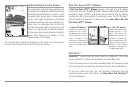
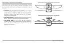
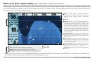
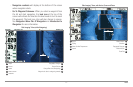
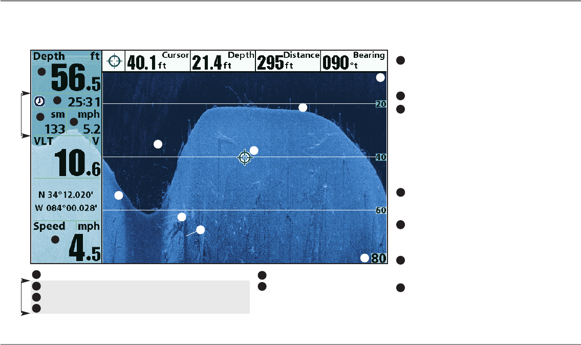
What’s on the Down Imaging™ Display
What’s on the Down Imaging™ Display
(858c DI, 958c DI, 898c SI, and 998c SI Combo models only)
Down Imaging™ uses unique sonar technology to provide information about the area directly below your boat. The razor-thin, high- definition profiling beams
produce the detailed sonar data that you see on the display. Down Imaging™ reveals a variety of recognizable features so that you can interpret the structure
and bottom contour, including the following items:
NOTE: Entries in this view that list (with Temp/Speed or GPS Receiver) are available if either device is connected to the 800/900 Series™ Fishing System. If both devices are
connected, then only the information from the GPS receiver will be displayed on the view.
3
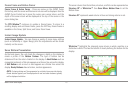
Freeze Frame & Zoom - Use the 4-WAY Cursor Control key to
move the cursor to an area on the screen, and press the
ZOOM+ keyto seethe sonar returns in greater detail.
Topography Changes - The light part of the display shows
where the beam is hitting hard bottom or rising terrain. The
dark part of the display indicates soft bottom (sand, mud) or
descending terrain.
Depth - Waterdepth canbe set to alarm whenthe waterbecomes tooshallow.
Timer -ElapsedtimewithSpeedaccessoryorGPSReceiver.
Structure
2
Distance- DistancetraveledwithSpeedaccessoryorGPSReceiver.
AverageSpeed-AveragespeedreadingwithSpeedaccessoryorGPSReceiver.
4
Shadows - Result from a lack of reflected sonar from a
particular area and can be as valuable for interpretation than
the sonar reflected by the object itself. Use shadows to help
yousee theimage in3 dimensions,oriented inspace. You can
gain insightinto theactual shapeof anobject, orthe depth to
which it has sunk into the bottom, through shadows on the
display. Objects standing on the bottom cast a sonar shadow.
The longer the shadow, the taller the object. Fish also cast
shadows. You can use the shadow to interpret how close the
fish is tothe bottom.
9
Upper Range
5
4
1
2
3
7
Triplog
Triplog
10
12
13
8
Clouded Area may indicate abait ball and White Streaks may
indicate fish.
Lower Range
6
Speed - If a GPS Receiver or Temp/Speed accessory is
connected, the Fishing System can display the speed of the
boat and can keep a Triplog of nautical or statute miles
traveled.
7
Bottom Return - Use the appearanceof the bottom return to
determine bottomhardness. Rock andgravel provide a clearer
sonar return than mud and sand because hard objects reflect
sonar better thansoft objects.
11
1
3
13
11
12
5
6
10
8
9