


BENDIX/KING KLN 90B
Rev 5, April/2003 10521I05.TDC Page A-5
1.2 RS-232 OUTPUTS
1.2.1 NAVIGATION AND SELF-TEST DATA
RS-232 data will be output with the following format:
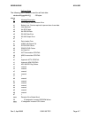
<STX><id><dddd><it><id><dddd><it>...<id><dddd><it><ETX>
<STX> ASCII start of text character
<id> item designator
<dddd> item data
<it> item terminator: <CR>
<ETX> ASCII end of text character
item field
desg item format width item description
---- ----------- ----- ----------------
1234567890
A s dd mmhh 9 present latitude
s=sign: N for north, S for south
dd=degrees
mm=minutes
hh=hundredths of minutes
B s ddd mmhh10 present longitude
s=sign: E for east, W for west
ddd=degrees
mm=minutes
hh=hundredths of minutes
C ddd 3 track (magnetic) -- dashed if groundspeed < 2KT
ddd=degrees
D ddd 3 ground speed
ddd=knots
E ddddd 5 distance to active waypoint
ddddd=nm * 10
G sdddd 5 cross track error
s=sign: R for aircraft position right of course,
L for aircraft position left of course
dddd=nm * 100
I dddd 4 desired track (magnetic) * 10
dddd=degrees * 10
K ddddd 5 active waypoint identifier
ddddd=ASCII active waypoint identifier
L dddd 4 bearing to active waypoint (magnetic)
dddd=degrees * 10
Q sddd 4 magnetic variation
s=sign: E for east, W for west
ddd=degrees * 10
T --------- 9 this field will always be dashed