


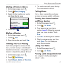
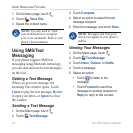
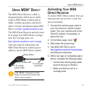

nüvi 680 Owner’s Manual 27
USinG MSn direct
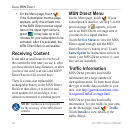
Trafc on Your Road
When you are not navigating a route and
a trafc delay is on your road, the Map
page displays a trafc icon, such as
. (See the list of icons on the
next page.) Touch the icon to view
information about the trafc delays on
the road ahead.
Trafc on Your Route
When calculating your route, the nüvi
examines the current trafc delays and
automatically optimizes the route for the
shortest time. You might still be routed
through trafc if it is the best route
available or no alternative roads exist.
If a severe trafc delay occurs on your
route while you are navigating, the nüvi
automatically recalculates the route to
avoid the severe delay.
The Map page displays when a
trafc delay is on your route. The
number in the icon represents the time
this delay added to your route. The delay
time has been automatically calculated
into the arrival time shown on the map.
To avoid trafc on your route:
1. On the Map page, touch .
2. Touch the text bar for more
information. If there is more than one
delay, touch Details.
3. Touch Avoid to avoid this delay.
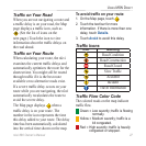
Trafc Icons
Icon Meaning
Road Condition
Road Construction
Road Closed
Slow Trafc
Accident
Incident
Travel Information
Trafc Flow Color Code
The colored roads on the map indicate
trafc ow.
Green = Low severity; trafc is owing
normally.
Yellow = Medium severity; trafc is a
bit congested.
Red = High severity; trafc is heavily
congested or stopped.