


36
Part Three: Section 2
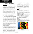
TAWS Operation
General Database Information
Garmin TAWS uses terrain and obstacle informa-
tion supplied by government sources. The data under-
goes verification by Garmin to confirm accuracy of
thecontent,perTSO-C151b.However, the displayed
information should never be understood as being
all-inclusive. Pilots must familiarize themselves
with the appropriate charts for safe flight.
NOTE: The data contained in the terrain and obstacle
databases comes from government agencies. Garmin accu-
rately processes and cross-validates the data, but cannot
guarantee the accuracy and completeness of the data.
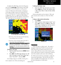
The terrain/obstacle databases are contained on a
datacard which is inserted in the right-most slot of the
400W/500WSeriesunits.
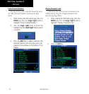
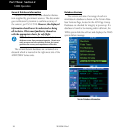
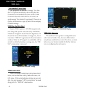
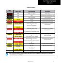
Database Versions
The version and area of coverage of each ter-
rain/obstacledatabaseisshownontheTerrainData-
baseVersionsPage,locatedintheAUXPageGroup.
Databasesarecheckedforintegrityatpower-up.Ifa
database is found to be missing and/or deficient, the
TAWS system fails the self-test and displays the TAWS
system failure message.
Terrain Database Information
190-00356-30 Rev F