


8
TIS Controls and Display
Part One: Section 2
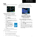
Highlighting TIS Traffic Using Map Page Panning
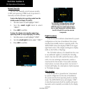
Another Map Page feature is panning, which allows
you to move the map beyond its current limits without
adjustingthemapscale.Whenyouselectthepanning
function—bypressingthesmall right knob—a
target pointer will flash on the map display. A window
also appears at the top of the map display showing
the latitude/longitude position of the pointer, plus the
bearing and distance to the pointer from your present
position.
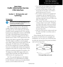
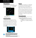
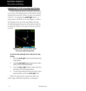
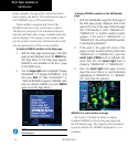
Displaying traffic range and altitude separa-
tion using the Map Panning feature.
To activate the panning feature and pan the map
display:
1. Press the small right knob to activate the panning
target pointer.
2. Turn the small right knob to move up (turn clock-
wise) or down (counterclockwise).
3. Turn the large right knob to move right (turn
clockwise) or left (counterclockwise).
4. To cancel the panning function and return to your
present position, press the small right knob.
When the target pointer is placed on traffic, the
traffic range and altitude separation are displayed.
190-00356-30 Rev F