


Garmin G3X MFD Quick Reference Guide
190-01055-00 Rev. A
15
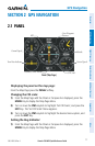
GPS Navigation
Overview GPS Navigation Flight Planning Hazard Avoidance Additional Features Appendices Index
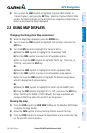
2)
Press the CLR Key again. ‘CLEAR-2’ appears below the map range and
airspace boundary detail is removed from the map.
3)
Press the CLR Key again. ‘CLEAR-3’ appears below the map range. Only
the waypoints and navaids that are part of the current flight plan appear on
the map.
4)
Press the CLR Key again to return ‘ALL’ detail to the map.
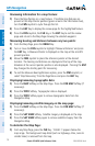
2.4 WAYPOINTS
Selecting an airport for review by identifier, facility name, or loca-
tion:
1)
From the Waypoint (WPT) Page, press the INFO Softkey.
2)
Press the FMS Joystick to activate the cursor.
3)
Turn the FMS Joystick clockwise to begin entering a waypoint identifier
(turning it counter-clockwise brings up the waypoint selection submenu -
press the CLR Key to remove it), or move the FMS Joystick to select the
facility name, or city field.
4)
Press the ENT Key.
Selecting a runway:
1)
With the Waypoint (WPT) Page displayed, press the INFO Softkey.
2)
Press the FMS Joystick to activate the cursor.
3)
Turn the FMS Joystick clockwise to begin entering a waypoint identifier for
the desired runway (turning it counter-clockwise brings up the waypoint
selection submenu - press the CLR Key to remove it), or move the FMS
Joystick to select the facility name, or city field.
4)
Press the ENT Key.
5)
Move the FMS Joystick to place the cursor in the ‘Runways’ Box, on the
runway designator.
6)
Turn the FMS Joystick to display the desired runway (if more than one) for
the selected airport.
Viewing additional information for a frequency:
1)
With the Waypoint (WPT) Page displayed, press the INFO Softkey.
2)
Press the FMS Joystick to activate the cursor.