


Garmin G3X MFD Quick Reference Guide
190-01055-00 Rev. A
14
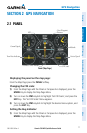
GPS Navigation
OverviewGPS NavigationFlight PlanningHazard AvoidanceAdditional FeaturesAppendicesIndex
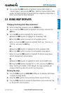
Reviewing information for a map feature:
1)
Place the Map Pointer on a map feature. If multiple map features are
present at the Map Pointer position (green arrow in the information box),
turn the FMS Joystick to cycle through the list.
2)
Press the ENT Key to display the review page for the highlighted feature.
3)
Press the FMS Joystick, the CLR Key, or the ENT Key to exit the review
page and return to the Map Page showing the selected waypoint.
Measuring bearing and distance between any two points:
1)
From the Map Page, press the MENU Key.
2)
Turn or move the FMS Joystick to highlight ‘Measure Distance’ and press
the ENT Key. A Measure Pointer is displayed on the map at the aircraft’s
present position.
3)
Move the FMS Joystick to place the reference pointer at the desired
location. The bearing and distance are displayed at the top of the map.
Elevation at the current pointer position is also displayed. Pressing the ENT
Key changes the starting point for measuring.
4)
To exit the Measure Bearing/Distance option, press the FMS Joystick; or
select ‘Stop Measuring’ from the Page Menu and press the ENT Key.
Displaying/removing topographic data:
1)
Press the MAP Softkey on the Map Page. Press the VFR MAP Softkey (if
necessary).
2)
Press the TOPO Softkey. Topographic data is displayed.
3)
Press the TOPO Softkey again to remove topographic data from the
Navigation Map.
Displaying/removing satellite imagery on the map page:
1)
Press the MAP Softkey on the Map Page. Press the VFR MAP Softkey (if
necessary).
2)
Press the SAT VIEW Softkey. Satellite imagery is displayed on the map.
3)
Press the SAT VIEW Softkey again to remove satellite imagery from the
Navigation Map.
To declutter the Map Page:
1)
From any Map Page, press the CLR Key. ‘CLEAR-1’ appears below the
map range. The background map detail (such as highways, cities, rivers &
smaller lakes) is removed from the map.