


Garmin G1000 Pilot’s Guide for the Beechcraft A36/G36
190-00595-01 Rev. B
282
HAZARD AVOIDANCE
SYSTEM
OVERVIEW
FLIGHT
INSTRUMENTS
EIS
AUDIO PANEL
& CNS
FLIGHT
MANAGEMENT
HAZARD
AVOIDANCE
AFCS
ADDITIONAL
FEATURES
APPENDICESINDEX
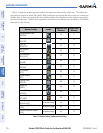
NEXRAD LIMITATIONS
NEXRAD radar images may have certain limitations:
• NEXRAD base reflectivity does not provide sufficient information to determine cloud layers or precipitation
characteristics (wet hail vs. rain). For example, it is not possible to distinguish between wet snow, wet
hail, and rain.
• NEXRAD base reflectivity is sampled at the minimum antenna elevation angle. An individual NEXRAD
site cannot depict high altitude storms at close ranges. It has no information about storms directly over
the site.
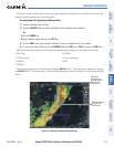
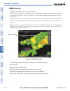
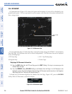
• When zoomed in to a range of 30 nm, each square block on the display represents an area of four square
kilometers. The intensity level reflected by each square represents the
highest
level of NEXRAD data
sampled within the area (Figure 6-12).
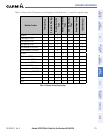
Figure 6-12 NEXRAD Data - Zoomed
Block Area is 4 km
2
The following may cause abnormalities in displayed NEXRAD radar images:
• Ground clutter
• Strobes and spurious radar data
• Sun strobes (when the radar antenna points directly at the sun)
• Interference from buildings or mountains, which may cause shadows
• Metallic dust from military aircraft, which can cause alterations in radar scans