


190-00595-01 Rev. B
Garmin G1000 Pilot’s Guide for the Beechcraft A36/G36
271
HAZARD AVOIDANCE
SYSTEM
OVERVIEW
FLIGHT
INSTRUMENTS
EIS
AUDIO PANEL
& CNS
FLIGHT
MANAGEMENT
HAZARD
AVOIDANCE
AFCS
ADDITIONAL
FEATURES
APPENDICES INDEX
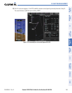
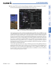
SECTION 6 HAZARD AVOIDANCE
The G1000 hazard avoidance features are designed to provide advisory information with regard to potential
hazards to flight safety associated with weather, terrain, and air traffic.
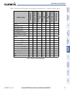
This section is divided into the following groups:
Weather
• GDL 69A XM
®
Satellite Weather
• L-3 STORMSCOPE
®
WX-500 Series II Weather Mapping Sensor (Optional)
Terrain Avoidance
• Terrain Awareness and Warning System (TAWS)
Traffic
• Traffic Information Service (TIS)
• L-3 SKYWATCH
®
HP (SKY497) Traffic Advisory System (TAS) (Optional)
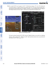
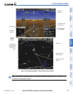
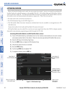
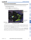
6.1 XM SATELLITE WEATHER
NOTE: XM Satellite Weather data provides information for avoiding hazardous weather. Do not utilize XM
Weather information to penetrate hazardous weather.
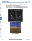
XM Satellite Weather is provided through the GDL 69A, a remote-mounted data-link satellite receiver. Received
graphical weather information and associated text is displayed on the Multi Function Display (MFD) and the
Primary Flight Display (PFD) Inset Map. The GDL 69A can also receive XM Satellite Radio
®
entertainment
services. Both weather data and entertainment programming operate in the S-band frequency range to provide
continuous reception capabilities at any altitude throughout North America.
XM Satellite Radio services are subscription-based. For more information on specific service packages, visit
www.xmradio.com.