


Garmin G1000 Cockpit Reference Guide for the DA42-L360
190-01062-01 Rev. A
46
Additional Features
Flight
InstrumentsEIS
Nav/Com/
XPDR/AudioAFCSGPS Nav
Flight
PlanningProcedures
Hazard
Avoidance
Additional
Features
Abnormal
Operation
Annun/
AlertsAppendixIndex
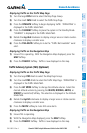
Displaying Pathways
1)
Press the PFD Softkey.
2)
Press the SYN VIS Softkey.
3)
If not already enabled, press the SYN TERR Softkey.
4)
Press the PATHWAY Softkey.
5)
Press the BACK Softkey to return to the previous page.
Displaying Heading on the Horizon
1)
Press the PFD Softkey.
2)
Press the SYN VIS Softkey.
3)
If not already enabled, press the SYN TERR Softkey.
4)
Press the HRZN HDG Softkey.
5)
Press the BACK Softkey to return to the previous page.
Displaying Airport Signs
1)
Press the PFD Softkey.
2)
Press the SYN VIS Softkey.
3)
If not already enabled, press the SYN TERR Softkey.
4)
Press the APTSIGNS Softkey.
5)
Press the BACK Softkey to return to the previous page.
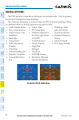
TERMINAL PROCEDURE CHARTS
NOTE: With the availability of SafeTaxi
®
, ChartView, or FliteCharts
®
, it may
be necessary to carry another source of charts on-board the aircraft.
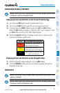
SafeTaxi
®
SafeTaxi
®
is an enhanced feature that gives greater map detail as the map range
is adjusted in on the airport. The airport display on the map reveals runways with
numbers, taxiways identifiers, and airport landmarks including ramps, buildings,
control towers, and other prominent features. Resolution is greater at lower map
ranges. The aircraft symbol provides situational awareness while taxiing.
Pressing the DCLTR Softkey (declutter) once removes the taxiway markings and
airport identification labels. Pressing the DCLTR Softkey twice removes VOR station
ID, the VOR symbol, and intersection names if within the airport plan view. Pressing