


Garmin G1000 Cockpit Reference Guide for the DA42-L360
190-01062-01 Rev. A
42
Hazard Avoidance
Flight
InstrumentsEIS
Nav/Com/
XPDR/AudioAFCSGPS Nav
Flight
PlanningProcedures
Hazard
Avoidance
Additional
Features
Abnormal
Operation
Annun/
AlertsAppendixIndex
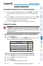
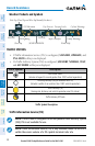
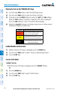
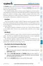
Display Terrain on the TERRAIN-SVS Page
1)
Turn the large FMS Knob to select the Map Page Group.
2)
Turn the small FMS Knob to select the Terrain-SVS Page.
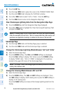
3)
If desired, press the VIEW Softkey to access the ARC and 360 softkeys.
When the ARC Softkey is selected, a radar-like 120° view is displayed.
Press the 360 Softkey to return to the 360° default display.
4)
Rotate the Joystick clockwise to display a larger area or rotate counter-
clockwise to display a smaller area.
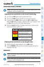
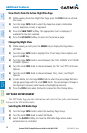
Color Terrain/Obstacle Location
Red
Terrain/Obstacle above or within 100’
below current aircraft altitude.
Yellow
Terrain/Obstacle between 100’ and
1000’ below current aircraft altitude.
Black
Terrain/Obstacle is more than 1000’
below aircraft altitude.
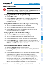
Enable/Disable Aviation Data
1)
While the Terrain-SVS Page is displayed, press the MENU Key.
2)
Turn the small FMS Knob to select “Show (or Hide) Aviation Data”.
3)
Press the ENT Key.
Terrain-SVS Inhibit
Inhibit Terrain
While the Terrain-SVS Page is displayed, press the INHIBIT Softkey.
Or
:
1)
Press the MENU Key.
2)
Turn the small FMS Knob to select ‘Inhibit Terrain’.
3)
Press the ENT Key.