


Garmin G1000 Cockpit Reference Guide for the DA42-L360
190-01062-01 Rev. A
35
Hazard Avoidance
Flight
Instruments EIS
Nav/Com/
XPDR/Audio AFCS GPS Nav
Flight
Planning Procedures
Hazard
Avoidance
Additional
Features
Abnormal
Operation
Annun/
Alerts Appendix Index
HAZARD AVOIDANCE
CUSTOMIZING THE HAZARD DISPLAYS ON THE NAVIGATION MAP
1)
With the Navigation Map Page displayed, press the MENU Key to display
the Navigation Map Page Menu. The cursor flashes on the ‘Map Setup’
option.
2)
Press the ENT Key. The Map Setup Menu is displayed. Turn the small FMS
Knob to select ‘Weather’ to customize the display of weather features.
Select ‘Traffic’ to customize the display of traffic.
3)
Press the small FMS Knob to return to the Navigation Map Page.
STORMSCOPE
®
(OPTIONAL)
WARNING: The Stormscope system is not intended to be used for hazardous
thunderstorm penetration. Weather information on the G1000 MFD is
approved for weather avoidance only. Refer to the WX-500 Pilot’s Guide for
detailed operation.
Displaying Stormscope Lightning Data on the Navigation Map Page
1)
Press the MAP Softkey.
2)
Press the STRMSCP Softkey. Press the STRMSCP Softkey again to remove
Stormscope Lightning Data from the Navigation Map Page.
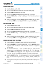
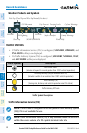
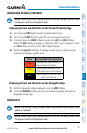
Lightning Age Symbol
Strike is less than 6 seconds old
Strike is between 6 and 60 seconds old
Strike is between 1 and 2 minutes old
Strike is between 2 and 3 minutes old
Select ‘Cell’ or ‘Strike’ as the Stormscope Lightning Mode
1)
Press the MENU Key (with the Navigation Map Page displayed).
2)
Turn either FMS Knob to highlight ‘Map Setup’.
3)
Press the ENT Key.
4)
Turn the small FMS Knob to highlight ‘Weather’.