


10 aera 500 Series Owner’s Manual
Where To?
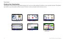
Finding a Place Using the
Map
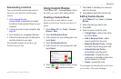
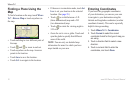
To nd a location on the map, touch Where
To? > Browse Map or touch anywhere on
the map.
Touch and drag to view different parts of
the map.
Touch and to zoom in and out.
Touch anywhere on the map. An arrow
points to the location.
Touch Save to save this location.
Touch Go! to navigate to the location.
•
•
•
•
•
If the aera is in simulator mode, touch Set
Loc. to set your location to the selected
location. (See page 28.)
Touch to switch between a 3-D
(three-dimensional) map and a 2-D
(two-dimensional) map.
Touch to rotate the viewing angle in
3-D view.
Zoom far out to view a globe. Touch and
spin the globe to quickly nd different
areas of the world.
NOTE: You can only see detailed map
information for areas for which you have
maps loaded on your aera.
•
•
•
•
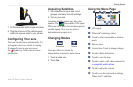
Entering Coordinates
If you know the geographic coordinates
of your destination, you can use your aera
to navigate to your destination using the
latitude and longitude coordinates (or other
coordinate formats). This can be especially
helpful when geocaching.
1. Touch Where To? > Coordinates.
2. Touch Format to select the correct
coordinate format for the type of map you
are using.
3. Touch a direction eld to select a new
direction.
4. Touch a numeric eld to enter the
coordinates, and touch Done.