


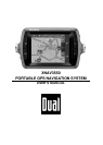


USER’S MANUAL XNAV3550
Before you begin - 7 -
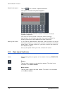
2.1 The basic principle of navigation
XNAV3550 The time of complicated and frustrating inquiries on the right way
in folded maps is over. From now on XNAV3550, your
navigation system, will guide you, based on satellite information,
quickly and safely to your destination.
GPS based
navigation
The Global Positioning System (GPS) network was originally been
developed in the 70s, as a weapon guidance system for the
American armed forces.
GPS is based on 24 satellites, which are in orbit round the earth
and which are permanently emitting signals. The GPS receiver
receives those signals and calculates, based on the runtime of
the signals, his distance from the respective satellites. This
information serves for calculation your current geographic
position.
The signals of at least three satellites are needed to determine
the longitude and the latitude. With the signals of at least four
satellites the elevation may be calculated, too. The determination
has an accuracy of about 9 feet.
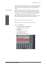
Navigation with GPS The delivered maps contain the geographic coordinates of the
points of interest, streets and cities they represent. Thus the
navigation system can calculate a route from a given start point
to a given destination point.
In case your navigation system receives the signals of at least
three satellites it may determine your current position and
represents it on the map. This position may then serve as start
point for navigation purposes.
As the determination and representation of your position is
carried out once a second, you may watch your movements on
the map.