


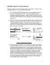

Logging is supported from different modes within the Locator. Data is logged
when an iD marker is read or programmed and when exiting the Cable / Sonde
depth mode. If a non-RFID marker is attempted to be read, the data is also
processed and saved by the GPS device.
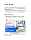
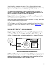
In GIS mode, whether you use the 3M™ ArcPad™ scripts, or Thales™
MobileMapper™ Pro, the data records sent from the Locator are used to create
different layers on the map based on the record type “description.”
This unique feature of the interface with the 3M™ Dynatel™ M-series Locator
enables the GPS devices to log iD marker record or Trace path records with the
feature points and to group according to the description into different layers.
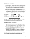
For example - Five iD markers have exactly the same information
programmed into them. All five contain the information, “Descrptn:
Abandoned”.
• The GPS device will identify all five with a feature name: ‘Abandoned’. As
a result, all of these markers will be grouped together as one layer.
• If the information contained in the marker does not include the label
‘Descrptn’, or if the information varies from marker to marker, the GPS
device will identify each iD marker as “Marker” and uses a subscript
number (sequentially incremented) for each map feature, thereafter.
• Passive markers will also have a feature name of "Marker", but will be
noted in the GPS device as “Not an iD marker”.
• For the Trace path, or cable locate mode, if the label “Descrptn” is not
included, it will be identified as “Trace”.
When the map, or the shape files are exported, all the layers in the Job and the
feature point data records are used by the GIS system.
In the GPS map, all markers will be grouped into separate layers. Each layer
may be turned on or off for viewing, which makes it easier to see separate
groups.
Note: If markers are not programmed with user data in the same order or have
different number of lines of user data, subgroups of feature names may occur.
For example - One marker has 2 user data lines and another has 3. Both
markers have the same "Descrptn": "Conduit",
• The feature name "Conduit" would be assigned for the first iD marker. The
second marker would have the feature name "Conduit1", indicating that
different information is available on each marker, even though both indicate a
‘conduit’ location.
• A third marker with a "Descrptn": "Conduit", with user data programmed in
yet, a different order would have the feature name "Conduit2", etc., etc..
6