


Installing and running 3M™ ArcPad™ application scripts
Using Trimble™ GeoXT™ and Thales™ MobileMapper™ CE.NET
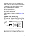
ArcPad™ is a stand-alone application that runs on the GPS device. Many GPS
devices including Trimble™ GeoXT™, Thales™ MobileMapper™ CE.NET
support ArcPad™.
3M™ provides the application scripts that would need to be installed on the GPS
device. These scripts provide interface to the 3M™ Dynatel™ Locator and the
ArcPad™ application / GPS device. The scripts are designed to provide Job
management functions and provide mapping functionality.
As the data records come in from the Locator, the record is matched against
previous records. If there is a matching record from an existing “Layer”, the
feature point is added to that layer with all the other GPS data. If the record
belongs to a new type of “description”, a new layer is automatically created and
the feature point is attached.
Please refer to the section “Mode 2 operation – GIS mode” for more details.
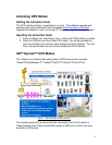
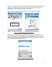
Installation of 3M™ ArcPad™ application scripts
It is expected that ArcPad™ application is already installed on the GPS device.
The 3M™ ArcPad™ application scripts run on GPS devices that support
Arcpad™ scripting. The scripts were tested on Trimble™ GeoXT™ and Thales™
MobileMapper™ CE.NET.
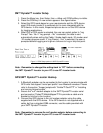
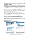
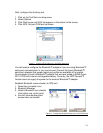
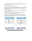
The installation of 3M
™ Arcpad™ scripts would involve copying the following
NINE files into the “Applets” folder of the Arcpad™ installation where Arcpad.exe
exists on the GPS device.
1. 3MLocator.bmp 2. IDShapefile.apl
3. IDShapefile.vbs 4. jobs.dbf
5. language.xml 6. Locator.apa
7. Locator.vbs 8. Sambaman.BMP
9. SambaMan.ico
These script files are provided in a zip file and can be downloaded from the 3M
™
website at www.3M.com/dynatel
The zip file needs to be extracted to a local folder.
Typically, Microsoft ActiveSync application can be used to explore the device.
11