


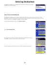
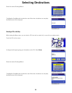
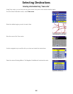
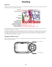

Travelling
54
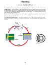
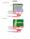
Map Screen
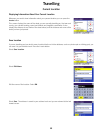
The Map screen is the most commonly used screen in the Magellan RoadMate. It provides you with detailed information
about where you are and where you are going.
As you travel, the Map screen constantly updates your location. It provides you with not only a map but also a visual
indication of where you are on the map.
If the Magellan RoadMate loses the satellite signal for more than 15 seconds and is unable to compute your location,
the display will automatically switch to the List of Directions screen. This will give you the information needed for your
next segment. While viewing the map screen, touching a POI icon will give you the option of routing to that point.
See “Selecting a POI on the Map” on page 51.
Changing the Map Zoom Levels
While in the Map screen, you can zoom in on (enlarge) the map or zoom out from (shrink) the map. The zoom levels
range from 130 ft. to 1665 mi.
Next Maneuver
Distance to Next Maneuver
Estimated Time to Destination
Position Cursor
Planned Route (pink)
Current Road
Next Road
POI Icon
Direction of Travel and
GPS Signal Strength
Direction of Destination
Distance to Destination
Zoom In Button
Zoom Out Button