


RoyalTek GPS Receiver REB-2000/REB-12R REV-2000 Operational Manual
12
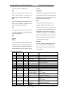
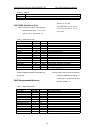
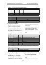
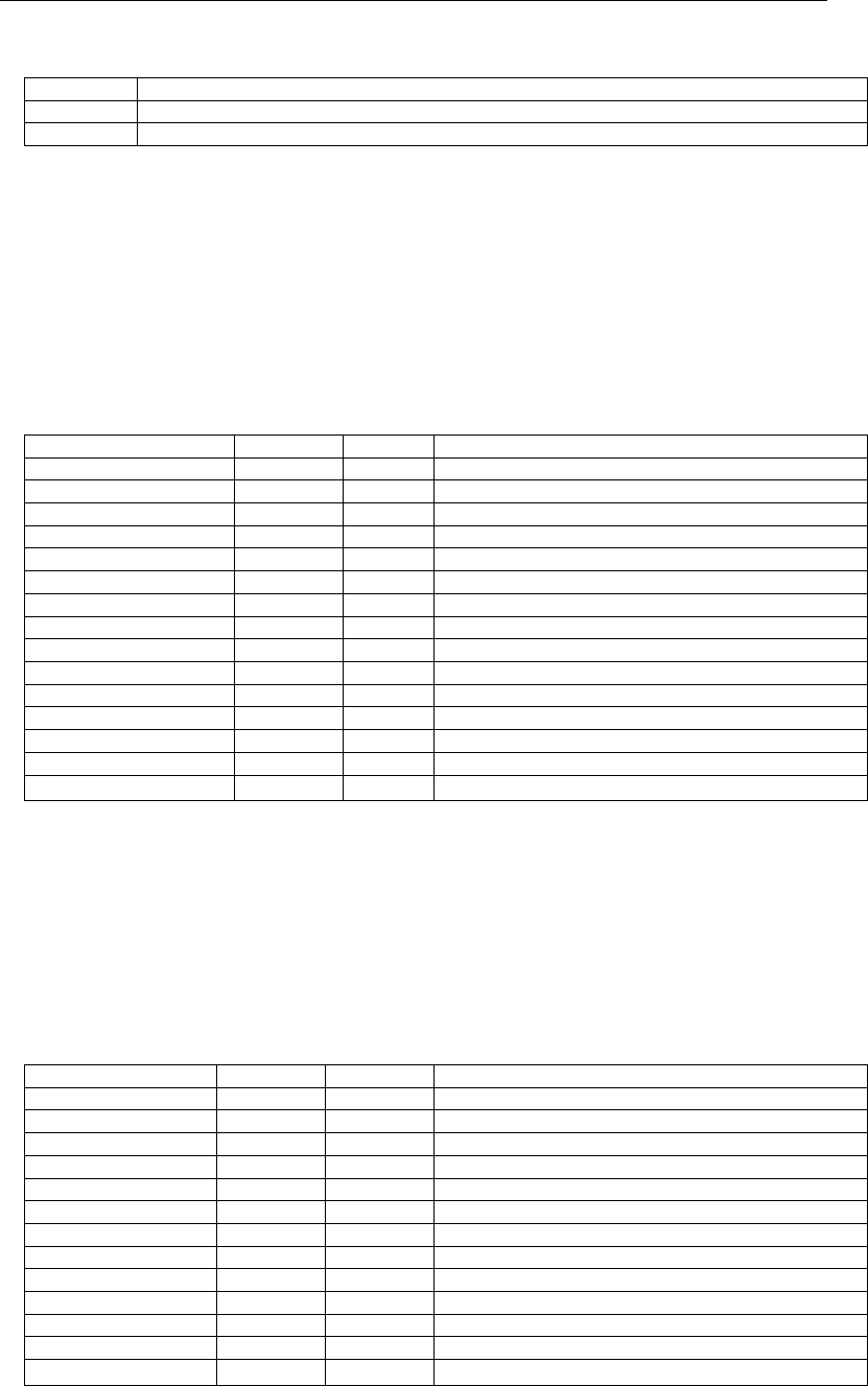
Table 4-2 Mode 2
Value Description
M Manual-forced to operate in 2D or 3D mode
A Automatic-allowed to automatically switch 2D/3D
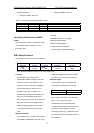
GSV-GNSS Satellites in View
Table 5 contains the values of the following
example: $GPGSV, 2, 1, 07, 07, 79,
048, 42, 02, 51, 062, 43, 26, 36,
256, 42, 27, 27, 138,
42*71$GPGSV, 2, 2, 07, 09, 23,
313, 42, 04, 19, 159, 41, 15, 12,
041, 42*41
Table 5 GGA Data Format
Name Example Units Description
Message ID $GPGSV GSV protocol header
Number of Messages
1
2 Range 1 to 3
Messages Number
1
1 Range 1 to 3
Satellites in View 07
Satellite ID 07 Channel 1(Range 1 to 32)
Elevation 79 degrees Channel 1(Maximum 90)
Azimuth 048 degrees Channel 1(True, Range 0 to 359)
SNR (C/No) 42 dBHz Range 0 to 99, null when not tracking
…. ….
Satellite ID 27 Channel 4(Range 1 to 32)
Elevation 27 degrees Channel 4(Maximum 90)
Azimuth 138 degrees Channel 4(True, Range 0 to 359)
SNR (C/No) 42 dBHz Range 0 to 99, null when not tracking
Checksum *71
<
CR
><
LF
>
End of message termination
1
Depending on the number of satellites
tracked multiple messages of GSV data may
be required.
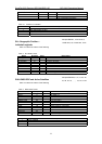
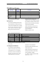
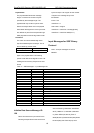
RMC-Recommended Minimum
Specific GNSS Data
Table 6 contains the values of the following
example: $GPRMC, 161229.487, A,
3723.2475, N, 12158.3416, W, 0.13,
309.62, 120598, ,*10
Table 6 GGA Data Format
Name Example Units Description
Message ID $GPRMC RMC protocol header
UTC Position 161229.487 hhmmss.sss
Status A A=data valid or V=data not valid
Latitude 3723.2475 ddmm.mmmm
N/S Indicator N N=north or S=south
Longitude 12158.3416 dddmm.mmmm
E/W Indicator W E=east or W=west
Speed Over Ground 0.13 knots
Course Over Ground 309.62 degrees True
Date 120598 ddmmyy
Magnetic Variation degrees E=east or W=west
Checksum *10
<
CR
><
LF
>
End of message termination