


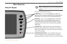
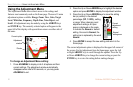
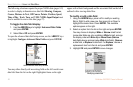

BASIC OPERATION > USING THE ADJUSTMENT MENU
20 Fishfinder 250/250C Owner’s Manual
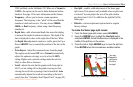
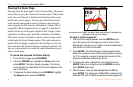
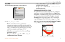
Pausing the Sonar Page
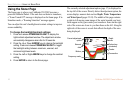
You may pause the Sonar page to stop it from scrolling. The paused
screen allows you to take a better look at sonar returns. When in this
mode, the word “Paused” is displayed at the bottom of the screen
and a Pointer cursor appears. You may move the Pointer around
on the paused sonar graph in order to reference sonar items and
mark waypoints for that location (if attached to a Garmin GPS or
compatible NMEA navigation device; see page 8). A data field is
displayed at the top of the graph with the Pointer’s depth, surface
temperature for that position, and GPS coordinates (if available).
This makes it easier to find and use objects such as stumps, rocks,
or brush piles for future fishing locations. The depth continues to
update while the display is paused, but the unit does not show any
new sonar data until the Sonar display is unpaused (resumed). You
may see a discontinuity from where the sonar information stops to
where it starts again.
To pause and unpause the Sonar display:
1. From the Sonar page, press ADJ/MENU.
2. Using the ARROW keys, highlight the Pause option and
press ENTER. The Sonar display is paused. The Pointer
cursor appears and data fields for the Pointer appear at the
top of the screen.
3. To unpause the Sonar display, press ADJ/MENU, highlight
the Resume option and press ENTER.
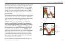
As you move the Pointer, the depth, temp, and position (if available) are
displayed at the top of the screen.
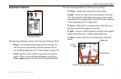
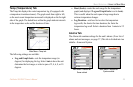
To mark a remote waypoint:
1. With the Sonar display paused, use the ARROW keys to
move the cursor onto the target you want to mark. A data
field appears with the cursor’s depth, surface temperature for
that position and GPS coordinates.
2. Press ENTER. The New Waypoint window appears with a
default four-character name (a three-digit number preceded
by “S” to designate a waypoint marked with sonar) and the
pointer’s coordinates automatically filled in.
3. To change the name, highlight the name field and press
ENTER. Make your changes using the ARROW keys and
press ENTER when done.
4. When finished, move the field highlight back to OK and
press ENTER. The unit sends a NMEA WPL sentence to the
attached GPS unit or NMEA navigational device (pages 8-9).