


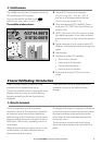

Northstar M121/M84 Installation and Operation Manual 29
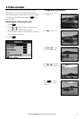
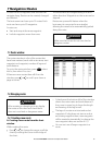
7-1 Routes window
The routes window is a list of the routes that
have been entered, each with route name, start
waypoint, end waypoint, number of legs and
total distance.
To go to the routes window, press
DISPLAY
, select
More, then select Routes.
If there are more routes than will fit on the
window, press
or to scroll up or down a
page at a time.
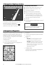
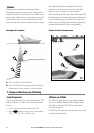
7-2-1 Creating a new route
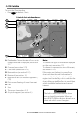
A. Creating a new route from the chart
window
While creating the route:
Press or to change the range; scroll the
chart by moving the cursor to the edge of
the chart.
• A data box at the bottom left of the window
shows the route name and total distance. If
the cursor is near a leg, it shows the length
and bearing of the leg as well.
The legs of a route must start and end at
waypoints. If a leg does not start or end at
an existing waypoint then a new waypoint
will be created automatically (to change the
new waypoint data, see section 6-2-1).
You can not use a Danger waypoint in a
route.
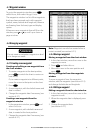
7-2 Managing routes
7 Navigation: Routes
A route is a list of waypoints that the boat can
navigate along. Routes can be created, changed
and deleted.
The Instrument can have up to 25 routes. Each
route can have up to 50 waypoints.
A route can:
Start and stop at the same waypoint .
Include waypoints more than once.
The Instrument can navigate along a route in
either direction. Waypoints on the route can be
skipped.
Routes are a powerful feature when the
Instrument is connected to an autopilot,
allowing the vessel to be automatically guided
along the route.
!
WARNING
Make sure that routes do not cross land or
dangerous water.
!
WARNING
After creating or changing a route, display
the route on the chart and check that it
does not cross land or dangerous water.