


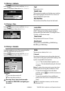

TRACKER 5380 Installation and Operation Manual
56
NAVMAN
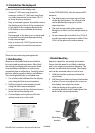
GENERAL
Size: 126 mm H x 126 mm W x 65 mm D (5.0” x
5.0” x 2.6”)
Display: 3.8” diagonal, TFT colour, 240 x 320
pixels
Backlight: Display and keys
Supply voltage
10 to 16 V DC.
Supply current: at 13.8 V
120 mA min - no backlighting
220 mA max - full backlighting
External beeper or light output: Switched to
ground to sound alarm, 30 V DC, 200 mA
maximum.
Operating temperature
0° to 50°C (32° to 122°F)
ALARMS:
User set: Arrival radius, anchor, XTE, danger,
low fuel (optional), loss of DGPS fix
Fixed: Loss of GPS fix
GPS NAVIGATION
Chart card: C-MAP™ NT-MAX, NT+ or NT
User card: 3.3 V C-MAP™
Waypoints: Up to 3000, with default or
user-defined alphanumeric names up to
eight characters.
Routes: 25 Routes, with up to 50 points each
Tracks: By time or distance, one track of 2000
points and four of 500 points.
Chart datums
121 Chart datums (see next page)
One user-defined map shift.
Chart scale: 0.05 to 4096 nm for chart (chart
dependent) down to 0.01 nm in plotter
mode.
FUEL COMPUTER
(Optional fuel sensor(s) required)
Engine types:
Outboard carburetted two stroke and EFI
petrol/gasoline engines: 50 to 300 hp.
Outboard four stroke petrol/gasoline
engines: 90 to 300 hp.
Inboard petrol/gasoline engines: 70 to 400
hp.
Flow rate:
Minimum: 5 litres per hour (1.3 U.S. gallons
per hour).
Maximum: 130 litres per hour (34 U.S.
gallons per hour).
COMMUNICATIONS
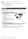
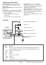
NavBus
Connection to other NAVMAN instruments.
NMEA
NMEA 0183 ver 2 4800 baud
• Inputs from compatible instruments: DBT,
DPT (preferred), GGA, GLL, GSA, GSV, MTW,
MWV, RMC, VHW, VTG
Outputs, for compatible instruments: APA,
APB, BWR, GGA, GLL, GSA, GSV, RMB, RMC,
VTG, XTE
STANDARDS COMPLIANCE
EMC:
USA: FCC Part 15 Class B.
Europe: (CE) EN301843-1:2004-06.
New Zealand and Australia: (C Tick)
EN60945 9.2 & 9.3.
Environment: IPx6/IPx7/CFR46 (with card
holder and connections in place).
Appendix A - Specifications