


TRACKER 5380 Installation and Operation Manual
20
NAVMAN
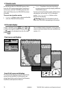
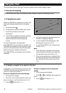
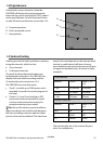
3-3 Distance and bearing calculator
The distance and bearing calculator can plot
a course of one or several legs and show the
bearing and length of each leg, as well as the
total distance along the course. The completed
course can be converted into a route.
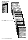
To use the distance and bearing calculator:
1 Press
until the chart display is
displayed. Press and select
Distance.
2 Move the cursor to the start of the first leg.
It does not matter if this point is a waypoint
or not. Press
.
3 To add a leg to the course, move the cursor
to the end of the leg. It does not matter if
this point is a waypoint or not. The display
shows the bearing and length of the leg, as
well as the total distance along the course.
Press
.
4 To remove the last leg from the course,
press
and select Remove.
5 Repeat the above two steps to enter the
whole course.
6 To save the new course as a route, press
and select Save. This also
saves any new points on the course as
new waypoints, with default names. If
necessary, edit the route later (see section
6-2-2) and edit any new waypoints later
(see section 5-2-3).
7 Finally, press
to return to the chart
display.
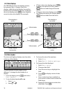
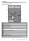
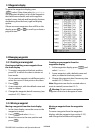
3-2-5 Finding places
To see places near the boat’s position, press
to switch to centre on boat mode.
To see places near a different point, move the
cursor to that point on the chart.
To find and display places of interest:
1 Press
and select Find.
2 Select the type of place: Waypoints, Routes,
Ports, Port services or Tide stations.
3 For a Port service, select the type of service
to find.
4 A list of places is displayed. If there are
more places than will fit on the display,
press
or to scroll up or down a
page at a time.
5 Select the place and press
. The chart
display changes to show the selected place
in the middle of the display.
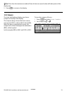
6 To see stored information about the
selected place, press
and select
Chart info (see section 3-2-4). To
display a tide chart for a selected tide
station, select
Tide height from the
chart info.