


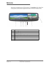
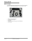
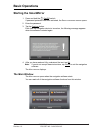

Welcome
Introducing the SmartMirror
About GPS navigation
GPS is based on a total of 24 satellites that circle the earth and are constantly trans-
mitting their position. The GPS receiver uses this data and calculates its own geo-
graphical position on the basis of the information transmitted by the various satellites.
For a sufficiently precise positioning it is necessary to obtain the data from at least
three satellites. With the data from 4 or more satellites the altitude above sea level can
also be ascertained. The determination has an accuracy of about 3 yards.
Once the navigation device has determined your position, it can be used as a starting
point for route calculation.
The map data on your navigation device includes the geographical coordinates of all
digitally recorded Points Of Interest (POIs), streets and places. This enables the
device to calculate a route between a starting point and a destination.
The calculation of the current position and its representation on the map takes place
once every second so your current position is always shown on the map.
If GPS reception is impaired, navigation is interrupted. The navigation software
remains active.
As soon as GPS reception is restored, the navigation system calculates any change
of position which has occurred in the meantime. Navigation may simply be continued.
Caution!
The United States government operates the Global Positioning System
(GPS) and is solely responsible for its accuracy and maintenance. Changes by the
United States government may affect the accuracy and performance of all GPS
equipment, including your personal navigation device.
Caution!
Ordinances or laws may restrict use of certain abilities of your navigation
device on public or private land
.
4 ESCORT SmartMirror User’s Guide 2009
ESCORT INC / NAVIGON INC Revision 1.0