DirectHelp
36 NAVIGON 2100 max | 2120 max User’s Guide December 2008
NAVIGON, INC. Version 2.1
Longitude/Latitude
The longitude and latitude of the location.
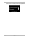
Show on Map
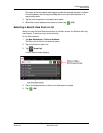
View your location on a map. Once a DirectHelp POI is selected, tapping this button
centers the map on the location of the selected POI. The selected POI is shown as a
gray circle. If you have enabled the display of the particular POI icon category (such
as Healthcare for Hospital) in map display, the icon and label of the selected POI
appears on the map. Changing the zoom level ( (
Zoom In) or (Zoom Out))
affects whether the icons display.
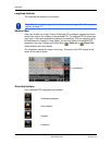
The crosshairs indicate the center of the map. The name of the POI closest to the
center of the map is shown.
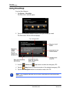
DirectHelp buttons
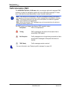
Four DirectHelp POI categories are available:
Roadside assistance
Police Station
Hospital
Pharmacy
Note: The format of the longitude and latitude can be changed. See “Selecting
options” on page 117.


