


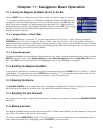

Chapter 10: Magellan RoadMate POI Manager
25
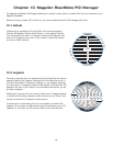
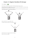
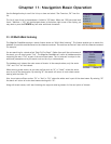
10.3 Altitude
Each location can also have an Altitude. Altitude is expressed
by how far the point is above or below the level of the ocean, or
Sea Level. For example, Los Angeles, California is about 300
feet above sea level. Death Valley, California is about 270 feet
below sea level.
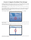
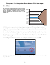
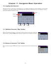
The POI Manager has a single interface for loading, adding, and deleting custom POIs from your Magellan RoadMate.
Using the USB cable provided with your Magellan RoadMate, insert the large end of the USB cable into an available USB
port on your computer.
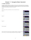
Turn on your Magellan RoadMate by sliding the Reset switch to position “1” (see “Top View” on page 6), or by pressing the
Suspend button (see “Front View” on page 4) to wake up the receiver if the unit is in “sleep” mode.
When the Warning screen appears, insert the small end of the USB cable into the USB port on your Magellan RoadMate. See
“Left Side View” on page 7.
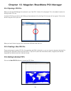
Launch the Magellan RoadMate Tools application. From the Magellan RoadMate Tools screen, click on
POI
.
The left side of the window shows the contents of your computer and the right side of the window shows the contents of the
Magellan RoadMate.
Sea Level 0’
20’ Above
40’ Above
60’ Above
80’ Above
100’ Above
100’ Below
80’ Below
60’ Below
40’ Below
20’ Below