


Appendix D
97
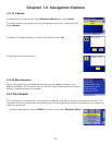
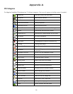
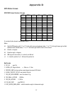
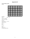
GPS Status Screen
GPS STATUS Screen Structure-first page
It is ordered by the channel number from 1 to 12.
Where:
d1: Satellite PRN number, with “e” or “E” to the right means got ephemeris data, “v” or “V” to the right means got verified
ephemeris data (double check). “E” or “V” also means got satellite time for this channel.
d2: Azimuth, in degrees
d3: Elevation angle, in degrees
d4: SNR (signal to noise ratio), it is ratio-Hz, not dB unit
c1: U – Used for position fix, U – Not used for position fix
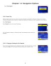
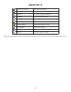
Bad fix code
0 PVT_OK :good fix
2 ILLEGAL_ALT: illegal altitude < -10km or > 17.5km
4 POSITION_JUMP: too big position jump between two epoch (300 miles)
5 ILLEGAL_VELOCITY_OR_ALT: max velocity 951mile
7 TOO_BIG_ACCELERATION max 15m around 1.5g
8 TOO_SMALL_ALTITUDE -10000 m
9 TOO_BIG_ALTITUDE 17,500 m
10 TOO_BIG_PDOP max PDOP 50
11 SATS_BELOW_MASK_ANGLE satellite elevation angle is below mask angle
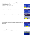
CH PRN AZ EL SNR U/N
01 d1 d2 d3 d4 c1
02 d1 d2 d3 d4 c1
03 d1 d2 d3 d4 c1
04 d1 d2 d3 d4 c1
05 d1 d2 d3 d4 c1
06 d1 d2 d3 d4 c1
07 d1 d2 d3 d4 c1
08 d1 d2 d3 d4 c1
09 d1 d2 d3 d4 c1
10 d1 d2 d3 d4 c1
11 d1 d2 d3 d4 c1
12 d1 d2 d3 d4 c1
13 d1 d2 d3 d4 c1
14 d1 d2 d3 d4 c1