


24
Chapter 10: Magellan RoadMate POI Manager
The Magellan RoadMate POI Manager enables you to transfer custom points of interest files from your computer to your
Magellan RoadMate.
Before we add any custom POI’s to the unit, you should understand how the POI Manager plots POIs.
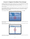
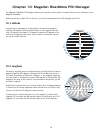
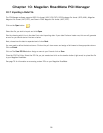
10.1 Latitude
Latitude can be expressed by dividing Earth into horizontal segments
totalling 180 degrees. Starting at the Equator, or zero degrees Latitude,
lines (or Parallels) are drawn in 10-degree increments 90 degrees to the
north and 90 degrees to the south. If your location is below the Equator,
you are at a South Latitude.
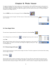
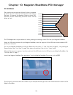
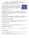
10.2 Longitude
Conversely, longitude lines can be expressed by dividing Earth into vertical
segments totalling 360 degrees. Starting at the Prime Meridian (which is
The Royal Observatory in Greenwich, England), or zero degrees Longitude,
lines are drawn in 10-degree increments 180 degrees to the West and 180
degrees to the East. If your location is on the western hemisphere, you are
at a West Longitude.
Additionally, to narrow down your location further, each 10-degree segment
is divided into 60 smaller segments called minutes and, still further, each
minute is divided into 60 segments called seconds.
To express this in coordinates, the city of Los Angeles is located at 34°
(degrees) 03’ (minutes) and 08 (seconds) North of the Equator, and 118°
(degrees) 14’ (minutes) and 42 (seconds) West of the Prime Meridian.
North Latitude
South Latitude
0°
10°
20°
30°
40°
50°
60°
70°
80°
90° (North Pole)
0°
10°
20°
30°
40°
50°
60°
70°
80°
90° (South Pole)
Equator
90°
West Longitude
East Longitude
70° 50° 30° 10° 10° 30° 50° 70° 90°
80° 60° 40° 20° 0° 20° 40° 60° 80°