


Chapter 1: Information
2
1.3 A Word on the Safe Usage of GPS Maps
Just like paper maps, maps on GPS devices vary greatly in terms of information included and visual presentation. Whether
topographical maps, roadmaps or marine charts, each map and the data it presents is designed for a specific purpose. For
example, marine charts will often present only a minimal representation of roadways and are not a substitute for street maps.
Topographic maps usually provide minimal detail about bodies of water and do not contain marine navigational markers.
Maps also vary widely in scale: the smaller the scale, the more detailed the map. Therefore, when using GPS maps (just as
with paper maps) it is important to consider what type of map you are using in your explorations and to use common sense.
1.3.1 From Source to Destination
Thales Navigation, maker of Magellan GPS products, is not a cartography company. We do not create the maps that are used
on our GPS devices. We seek to acquire map data from the best public and private sources available at the time of
publication. Thales Navigation licenses* topographical maps, roadmaps, marine charts and points of interest (POI) data
from commercial and governmental cartographic sources that provide raw map data. Thales Navigation processes and
compresses the raw data into a format that makes it presentable and manageable to work on our GPS devices. And to ensure
that our map data is as robust as possible, data from multiple sources are often combined to provide a better user experience
for our customers. This processing does not alter the landforms, coordinates or other spatial data that comes in the raw data.
The accuracy of the maps is fundamentally dependent on the source data used to create them. Map data changes frequently
due to both natural and man-made causes. As a result, governmental and commercial cartography companies must
continuously review, correct, and improve upon their map data. We release new versions of our maps on a regular basis to
reflect these changes.
After processing the data, we test the compatibility of the map with our GPS devices to ensure that the products we release
work properly on our GPS devices. We also beta-test our products to get customer feedback prior to release.
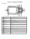
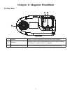
1.4 Placement of Your GPS Receiver for Optimal Satellite Reception
FIrstly, before considering signal reception, it is important to understand that your GPS receiver is a sensitive piece of
equipment. You should never place it in an area of your vehicle where it may be struck by other items, or where vibration may
cause it to strike other items or parts of the vehicle. The windshield mount included in the box allows you to place the
receiver in such a way that the antenna can receive the satellite signal through the windshield without being obstructed by
other parts of the vehicle. However, tinted windows or other reflective coatings may interfere with reception. In this case, it
may be required to attach an external antenna (optional). An external antenna provides faster satellite fix times and greater
signal strength. Because it is mounted outside of the vehicle, it is not affected by reflective coatings on windows and has an
unobstructed line of sight to the satellites. Other mounting solutions are available but may require an external antenna.
External conditions also affect GPS signal reception. Although weather conditions do not affect the signal, tall buildings and
trees, driving through canyons, wooded areas, or tunnels, and sitting in a garage or covered parking area will affect the GPS
signal. The GPS receiver constantly monitors and updated the GPS signal status and will reacquire the signal once it is clear
of any obstructions.
1.5 Signal Acquisition Time
The first time you use your Magellan RoadMate, or if you travel over 500 miles with the unit off, there may be a delay in
receiving the initial satellite fix; depending on your position and the position of the satellites, this could take 15 minutes or
more. Normal usage will receive the satellite fix much faster, but still may take several minutes. It is important to have your
antenna rotated upward and an unobstructed view of the sky to receive the best possible satellite signal.