


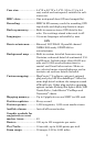

3
Case size: .........................5.4" H x 6.9" W x 3.4" D (13.8 x 17.6 x 8.6
cm); sealed and waterproof; suitable for salt-
water use.
MMC slots:.......................One waterproof door (SD card compatible).
Recording: ........................ MMC & SD memory cards for recording GPS
trip details and displaying charts or maps.
Back-up memory:...........Built-in memory stores GPS data for dec-
ades. User settings stored when unit is off.
Languages: ......................10; menu languages selectable by user.
GPS
Receiver/antenna: .........External; LGC-BAJA 12 parallel channel
NMEA 2000-ready GPS/WAAS re-
ceiver/antenna.
Background map: ..........Built-in custom, detailed Lowrance map.
Contains: enhanced detail of continental U.S.
and Hawaii. Includes more than 60,000 nav
aids and 10,000 wrecks/obstructions in
coastal and Great Lakes waters. Metro ar-
eas, selected major streets/highways and in-
terstate exit services details included.
Custom mapping:...........MapCreate™ 6 software optional; optional
plug and play LEI FreedomMaps™ offer the
same high detail without the computer work
of MapCreate. Other plug and play mapping
options include Fishing Hot Spots
®
Elite, LEI
NauticPath
™
, LakeMaster
®
ProMaps and
Navionics
®
charts.
Mapping memory: .........Up to 2 gigabytes on one MMC (or SD) card.
Position updates:...........Every second.
Position points: ..............1,000 waypoints; 1,000 event marker icons.
Audible alarms:..............Arrival/off-course/anchor.
Graphic symbols for
waypoints or event
marker icons:..................63.
Routes: .............................100; up to 100 waypoints per route.
Plot Trails:.......................10 savable; up to 9,999 points per trail.
Zoom range: ....................39 ranges; 0.02 to 4,000 miles.