


92
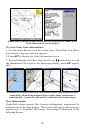
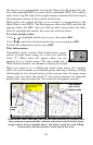
When you zoom in to a sufficiently small zoom range (0.8 nautical
mile), the icon becomes an animated arrow showing tidal current veloc-
ity and direction for the selected tidal station at the present time. At
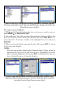
larger zoom ranges, you can select the boxed "C" icon and it becomes an
animated arrow with a pop-up name box (the name box disappears af-
ter a few seconds). Examples are displayed in the following figures.
To view Tidal Current information:
1. Use the arrow keys to move the cursor over a Tidal Current Station
icon. When it is selected, a pop-up name box appears.
2. Press
WPT to display the Tidal Current Information screen.
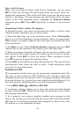
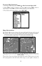
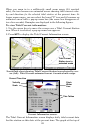
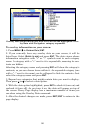
NauticPath chart showing Tidal Current Station icon selected by cur-
sor (left). Tidal Current animated icon at .8-nautical mile range.
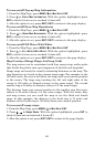
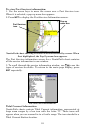
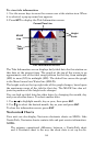
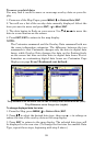
Current Information screen.
The Tidal Current Information screen displays daily tidal current data
for this station on this date at the present time. The graph at the top of
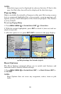
Cursor
lines
Tidal Current
Station icon in
animated mode
Slack
Water
Line
Velocity
Scale
Tide Tables
Current Time Line