


129
Section 7:
Advanced GPS Operations
Find Distance From Current Position
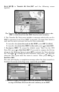
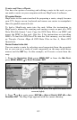
1. While on the Map Page press: MENU|↓ to FIND DISTANCE|ENT.
2. To find the distance to a specific location, center your cursor over the
position. A rubber band line appears, connecting your current position
to the cursor's location. The distance along that line will appear in a
pop-up box. The box also shows the bearing to location.
3. Press
EXIT to return to regular operation.
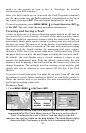
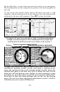
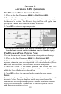
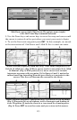
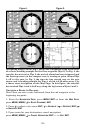
The distance from Dallas to Little Rock is 292.2 miles (left). The distance
from the boat's current position to the boat ramp is 0.58 miles (right).
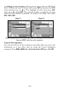
Find Distance From Point to Point
You can also measure distance between two other points on the map.
1. While on the Map Page press:
MENU|↓ to FIND DISTANCE|ENT.
2. Center your cursor over the first position. (A rubber band line
appears, connecting your current position to the cursor's location.) Press
ENT to set the first point, and the rubber band line disappears.
3. Move the cursor to the second position. The rubber band line
reappears, connecting the first point you set to the cursor. The distance
along that line will appear in a pop-up box.
4. Press
EXIT to clear the command and return to the page screen.
Icons
Icons are graphic symbols used to mark some location, personal point of
interest or event. They can be placed on the map screen, saved and
recalled later for navigational purposes. These are sometimes referred
to as event marker icons. The unit has 42 different symbols you can
pick from when creating an icon.