


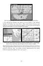

105
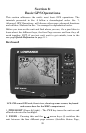
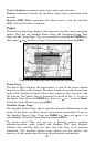
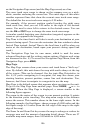
When navigating to a waypoint, the Navigation screen looks like the
following figure. Your ground speed, track, distance and bearing to
waypoint, and course are all shown digitally on this screen.
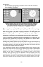
Navigation Page, backtracking a trail while creating a new trail.
In the example figure above, the driver is headed north (a 355º track)
toward a waypoint 358º (bearing) away. The cross track error range
(white corridor) is 0.20 miles either side of the course. The driver is
headed toward trail waypoint 1, which is 0.18 miles away. The vehicle
is virtually on course (off course only 49 feet to the left). Traveling at a
speed of 46 mph, the driver will arrive at the waypoint in 14 seconds.
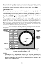
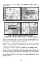
Speed (ground speed) is the velocity you are making over the ground. (If
you wish, you can customize the Speed window to display Closing
Speed instead. Closing Speed is also known as velocity made good. It's
the speed that you're making toward the waypoint. For instructions,
see the Customize Page Displays entry in Sec. 8.)
Track is the heading, or the current direction you are actually
traveling. Bearing is the direction of a line-of-sight from your present
position to the destination. No matter what direction you are steering,
the Bearing window shows the compass direction straight to the
destination from your location at the moment. Distance shows how far
it is to the waypoint you're navigating toward.
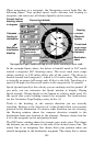
The Off Course window shows the current cross track error. This shows
the distance you are off-course to the side of the desired course line. The
course line is an imaginary line drawn from your position when you
started navigating to the destination waypoint. The course line is shown
Destination
name
Navigation
information
displays
Bearing
arrow
Cross track
error range
(off course
indicator)
Course line (dotted)
Waypoint
symbol
Current track or
heading, shown
in degrees
Compass
bearing to
destination
Trail line
(solid)
Left cross
track error