


101
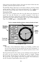
Track is the heading, or the current direction you are actually
traveling. Bearing is the direction of a line-of-sight from your present
position to the destination. No matter what direction you are steering,
the Bearing window shows the compass direction straight to the
destination from your location at the moment. Distance shows how far
it is to the waypoint you're navigating toward.
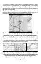
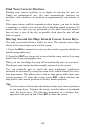
The Off Course window shows the current cross track error. This shows
the distance you are off-course to the side of the desired course line. The
course line is an imaginary line drawn from your position when you
started navigating to the destination waypoint. The course line is shown
on the Navigation Page screen (and the Map Page screen) as a line.
The cross track error range is shown on the compass rose as a wide,
white, corridor enclosing the course line. The outer edges of this white
corridor represent lines that show the current cross track error range.
The default for the cross track error range is 0.20 miles.
For example, if the present position symbol touches the right cross
track error line, then you are 0.20 miles to the right of the desired
course. You need to steer left to return to the desired course. You can
use the
ZIN or ZOUT keys to change the cross track error range.
A circular symbol depicting your destination (waypoint) appears on the
screen as you approach the waypoint.
Trip Time is the time that it will take to reach your destination at your
present closing speed. (You can also customize the time window to show
Arrival Time instead. Arrival Time is the local time it will be when you
arrive at the destination, based upon your present closing speed and
track.)
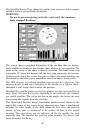
The Navigation Page has its own menu, which is used for some
advanced functions and for setting various options. (Options and setup
are discussed in Sec. 8.) To access the Navigation Page Menu, from the
Navigation Page, press
MENU.
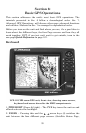
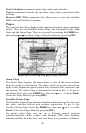
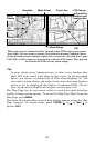
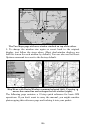
Map Page
The Map Page screens show your course and track from a "bird's-eye"
view. By default, this unit shows the map with north always at the top
of the screen. (This can be changed. See the topic Map Orientation, in
Sec. 8.) If you're navigating to a waypoint, the map also shows your
starting location, present position, course line and destination. You,
however, don't have to navigate to a waypoint to use the map.
Map Page is the default screen that appears when you turn on the unit.
To get to the Map Page from another page: Press
PAGES| → or ← to
MAP|EXIT. When the Map Page is displayed, a screen similar to the
following figure appears.