


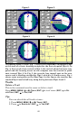
63
The Delete All Icons command will ask if you are sure. Press
← to
YES|ENT. All icons will be deleted from the map.
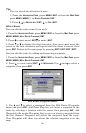
The Delete by Symbol command will launch the Select Symbol menu. Press
← or ↑ or → or ↓ to select the symbol to delete, then press ENT. A message
appears saying all icons with the selected symbol have been deleted.
The Delete from Map command will prompt you to move the cursor
over an icon to select it. After selecting the icon, press
ENT and it dis-
appears from the map.
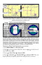
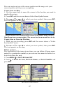
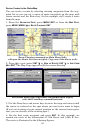
Navigate to an Icon
Use the Navigate to Cursor command, and use the cursor to select the
desired icon on the map.
1. Use arrow keys to center cursor cross-hair over the icon.
2. To navigate to the selected icon location press
MENU|ENT|EXIT. Fol-
low the course line on the Map Page or the compass-bearing arrow on the
Navigation Page.
Routes
A route is a series of waypoints linked together in an ordered sequence
to mark a course of travel. You can visualize a route as a string of
beads. The beads represent waypoints and the string represents the
course of travel connecting waypoint to waypoint.
The course from one waypoint to the next is a leg. Routes are composed
of one or more legs. The legs of all GPS routes are based on straight
lines between waypoints.
A route gives users the capability to navigate through several waypoints
without having to reprogram the unit after arriving at each waypoint.
The GPS unit allows you to navigate forward or backward through a
route. You can even begin navigating in the middle of a route!
Create and Save a Route
You have the option of creating and editing a route in the unit, or you
can make a route on your computer with our MapCreate 6 software.
PC-created Routes
MapCreate is the easiest method for preparing a route, simply because
your PC's larger screen, keyboard and mouse are easier to manipulate.
To load a MapCreate route into the GlobalMap, follow instructions in Map-
Create's manual for creating a route and saving it as part of a GPS Data
File (file format *.usr). Copy the GPS Data File to an MMC and insert the
MMC in the unit (See Sec. 2 for instructions on installing MMCs. To load
the GPS Data File into the GlobalMap's memory, see the entry on Transfer
Custom Maps & GPS Data Files in Sec. 3, Basic GPS Operations.).