


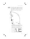


The Apollo GPS CDI may not be aligned with the
approach course, only the Nav receiver may be
used for course guidance.
3. Press
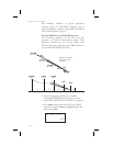
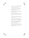
NAV on the Apollo GPS to display distance.
Note the distance to the IVDG DME to identify
the intersections TRAYL (D9.1 IVDG), BLAZR
(D5.2 IVDG), D2.2 step down, and, D0.2. Note
that if you enter the step-down waypoints into a
flight plan, the ILS bearing is 99° while the bearing
shown to the VOR-DME waypoint is 101°. This
difference occurs because the actual physical
locations for the DME antenna and the localizer
antenna are different.
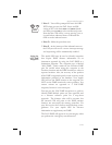
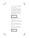
ete lIVDG 01:54
0.004 “
brg 101½ 5.65nm
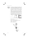
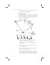
DME Data from ILS with Procedure Turn
This example uses the ILS DME approach to Rwy
21L at Prescott, Arizona.
1. After reaching the Drake (DRK) VOR, continue to
the HUMTY intersection to intercept the outbound
localizer course using your Nav receiver for course
guidance.
2. Before commencing the approach, press
DIRECT-TO. Select the IPRC LOC-DME waypoint
using the
LARGE and SMALL knobs, and then press
ENTER.
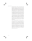
3. Press
NAV on the Apollo GPS to display distance.
Use your Apollo GPS for DME information to
identify the D10.1 point and the HUMTY (D7.2)
IAF intersection.
ete lIPRC 02:08
0.000 “
brg 209½ 7.17nm
9-71
Approach Examples