


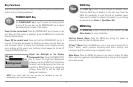
17
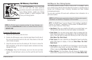
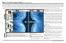
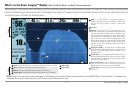
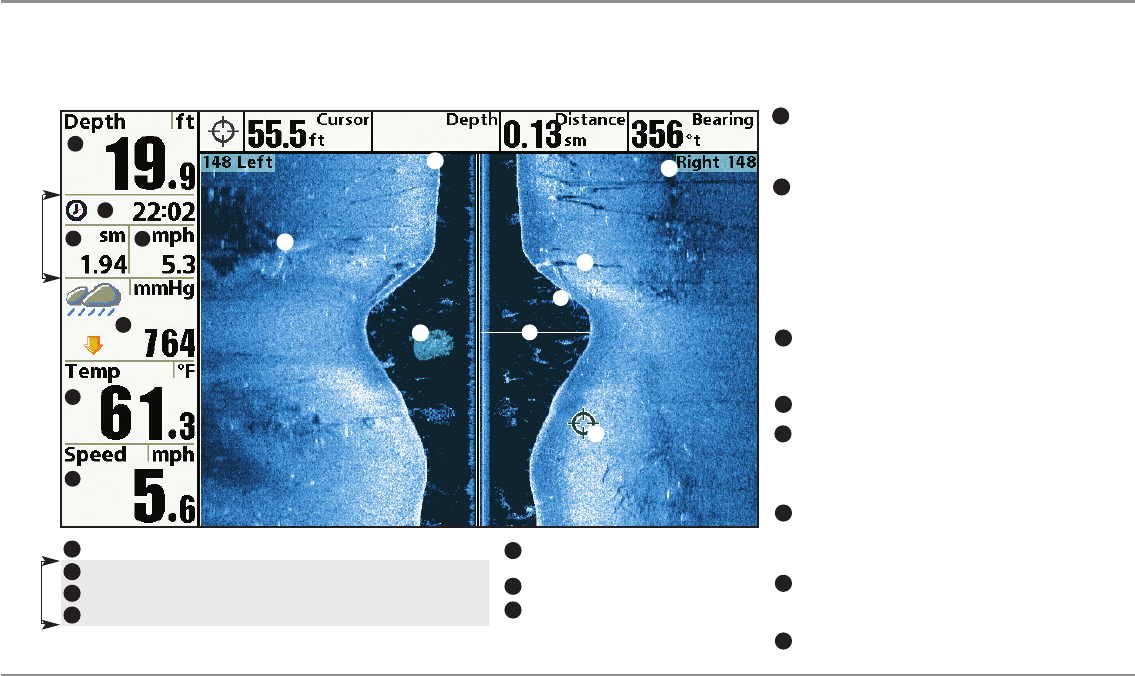
What’s on the SideImaging® Display
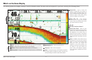
What’s on the Side Imaging® Display
(898c SI and 998c SI only)
Side Imaging® displays anumber of easily recognizable featuresthatallow for accurateinterpretationof bottomcontour and structure.ForSideImaging®,the bottom
composition determines the intensity of the sonar return. For example, rock and gravel provide a clearer sonar return than mud and sand because of their relative
density. Upward slopes that face the transducer reflect sonar better than downward slopes that face away from the transducer. You can find a number of easily
recognizable features on the Side Imaging® display that allow for accurate interpretation of bottom contour and structure, including the following items:
Watercolumn-Showstherelativedepthofthewaterunderthe
boatatagiventime.Variationsinthewidthofthewatercolumn
showvariationsinthedistancetothebottomastheboatpasses
over.
Shadows-Resultfromalackofreflectedsonarfromaparticular
areaandcan bemorevaluableforinterpretationthanthesonar
reflected by the object itself. Use shadows to help you see the
imagein 3 dimensions, oriented in space. You can gain insight
intothe actualshape of anobject,or thedepth to which it has
sunk intothe bottom, through shadows on the display. Objects
standing on the bottom cast a sonar shadow. The longer the
shadow, the taller the object. Fish also cast shadows. You can
usetheshadowto interprethowclosethefishisto thebottom.
Side Imaging® Range-Images shownon theright sideofthe
screen are located on the right side of your boat, and images
shownontheleftsideofthescreenarelocatedontheleftside
of your boat. In this illustration, the sonar is pinging 148 feet
on each side.
TopographyChanges-Thelightpartofthescreenshowswhere
thebeamishittinghardbottomorrisingterrain.Thedarkpartof
the screen indicates soft bottom (sand, mud) or descending
terrain.
Top of the Display - Information from the side beams are
displayed at the top of the screen. As new information is
received, the historical data scrolls down the screen. For the
most current information, watchthe top ofthe screen.
Clouded Area - May indicate a bait ball and White Streaks
may indicate fish.
Freeze Frame & Zoom - Use the 4-WAYCursor Controlkey to
move the cursor to an area on the screen, and press the
ZOOM+ keyto seethe sonar returns in greater detail.
Temperature -Watersurfacetemperature
BarometricPressure- Requiresoptional-
purchaseWeatherSense®
Speed -Ifa Speedaccessory orGPSReceiveris
attached, the Fishing System can display the
speed of the boat, and can keep a triplog of
nauticalorstatutemilestraveled.
BottomReturn
Distance - Distance traveledwith Speed accessory orGPS Receiver.
Average Speed- AveragespeedreadingwithSpeedaccessoryorGPSReceiver.
Timer -Elapsed timewith Speedaccessory or GPS Receiver.
Depth- Waterdepth;canbesettoalarmwhenthewaterbecomestooshallow.
1
3
6
7
6
5
1
2
3
4
Triplog
7
8
4
5
8
Triplog
10
11
10
9
12
12
14
15
13
14
15
9
2
13
11